GIS for Beginners #2: Learn Digitizing using QGIS

GIS for Beginners #2: Learn Digitizing using QGIS
MP4 | Video: AVC 1280x720 | Audio: AAC 44KHz 2ch | Duration: 1 Hours | Lec: 12 | 258 MB
Genre: eLearning | Language: English
MP4 | Video: AVC 1280x720 | Audio: AAC 44KHz 2ch | Duration: 1 Hours | Lec: 12 | 258 MB
Genre: eLearning | Language: English
Learn Digitizing using Equipment Every Office has
Attention Researchers, College Students And Professionals: Do You Want To Add GIS To Your Toolkit Without Having The Hassle Of Enrolling In A College GIS Course?
TAKE THE HEADACHE OUT OF DIGITIZING YOUR OWN GIS MAPS
Learn My Six-Step Process To DIGITIZE YOUR OWN PAPER MAPS Using Equipment Every Office Has.
Have you been trying to learn how to digitize your own map into GIS without any luck?
You have looked around the web but the information you find is incomplete, out-of-date and hard to follow.
That’s understandable because the best tutorials are usually for expensive commercial GIS’s and the lessons for the FREE, equally functional, Quantum GIS are mostly written by volunteers.
Fortunately, my GIS for Beginners #2: Learn Digitizing using QGIS course offers a solution. I teach you the beginners basics of digitizing your own maps in QGIS using videos and downloadable workbooks and datasets, Step-by-Step Follow-Along style.
It is as simple as watching the videos on your computer and following along with the exercises using the FREE Quantum GIS Software
Start now and you could be digitizing your own GIS maps this time tomorrow
Imagine what would be like to digitize your own field studies in a timely manner, OR to stumble across a paper map that’s essential to your project, and KNOW that you can digitize it YOURSELF TODAY, without the hassle of finding and waiting for someone else to digitize it for you.
My name is Ian Allan. I am a Masters graduate from Monash University in Melbourne Australia. While doing my post-graduate research, I co-authored the University’s first two GIS courses and taught both Grid Cell and Vector GIS to both Undergraduate and Graduate students.
Over the last 24 years I have authored and co-authored fifteen peer reviewed publications. I have worked professionally as a GIS researcher, taught GIS to thousands of students, and worked as a GIS consultant on projects as diverse as the following…
United Nations: Post tsunami strategic planning in Banda Ache
Australian Federal Government: National Broadband strategic assessment.
Victoria’s Department of Premier and Cabinet: Housing affordability modelling.
Local Government: Environmental sustainability modelling for planners,
Water industry: Buried water pipe condition modelling and ease-of-digging modelling
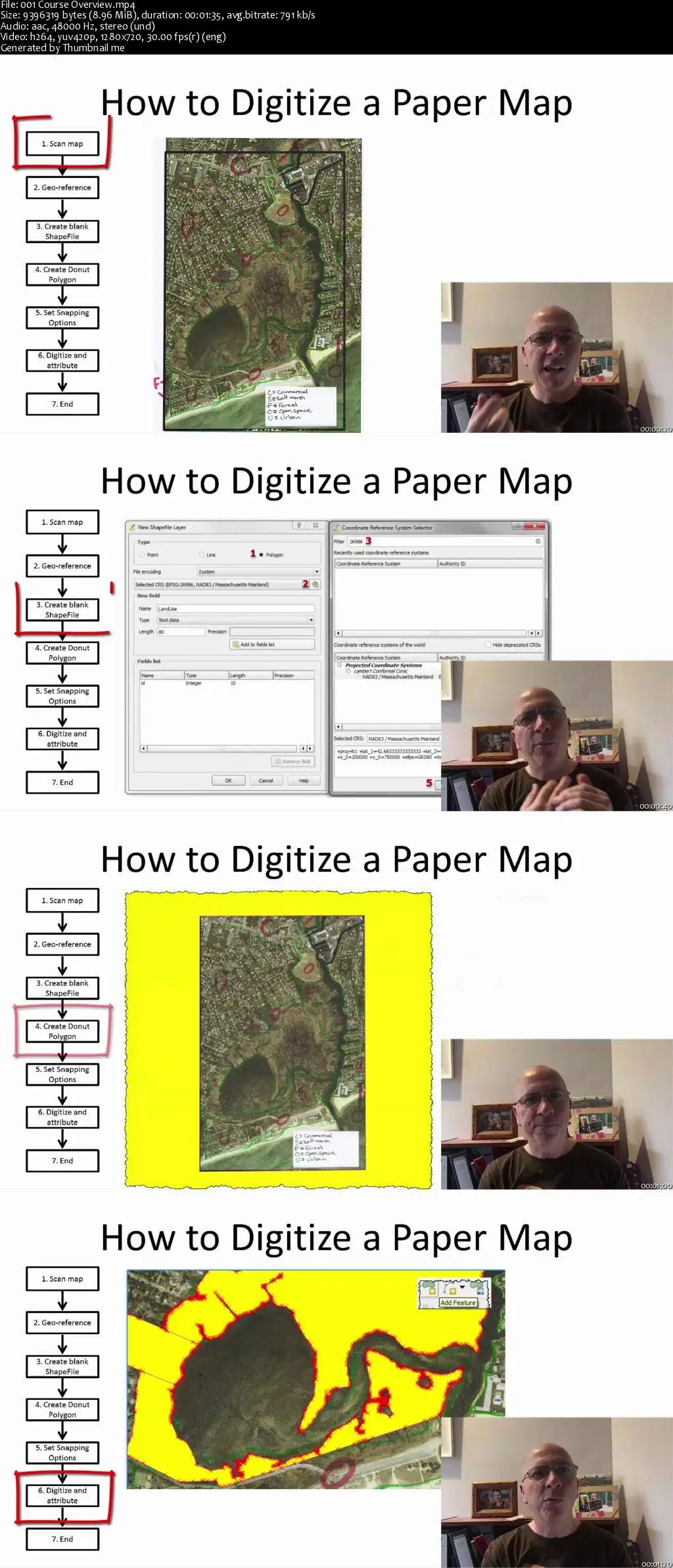
GIS for Beginners #2: Learn Digitizing using QGIS will teach you The SIX easy steps for digitizing a paper map (turn a Paper Map into a GIS map)
For the past 24 years I’ve been a GIS researcher teacher and consultant. Over 4600 students have enrolled in my GIS Udemy courses alone. Here’s what some of them have had to say about my teaching style…
GIS for Beginners #2: Learn Digitizing using QGIS