Machine Learning in GIS: Understand the Theory and Practice
Machine Learning in GIS: Understand the Theory and Practice
Video: .mp4 (1280x720, 30 fps(r)) | Audio: aac, 44100 Hz, 2ch | Size: 1.48 GB
Genre: eLearning Video | Duration: 17 lectures (2 hour, 49 mins) | Language: English
Geographic information systems and Remote Sensing in QGIS and Google Earth Engine
Video: .mp4 (1280x720, 30 fps(r)) | Audio: aac, 44100 Hz, 2ch | Size: 1.48 GB
Genre: eLearning Video | Duration: 17 lectures (2 hour, 49 mins) | Language: English
Geographic information systems and Remote Sensing in QGIS and Google Earth Engine
What you'll learn
Fully understand the basics of Machine Learning
Get an introduction to Geographic Information Systems (GIS), geodata types and GIS applications
Fully understand basics of Remote Sensing
Learn open source GIS and Remote Sensing software tools (QGIS, Google Earth Engine and others)
Fully understand the main types of Machine Learning and their applications in GIS
Learn about supervise and unsupervise learning and their applications in GIS
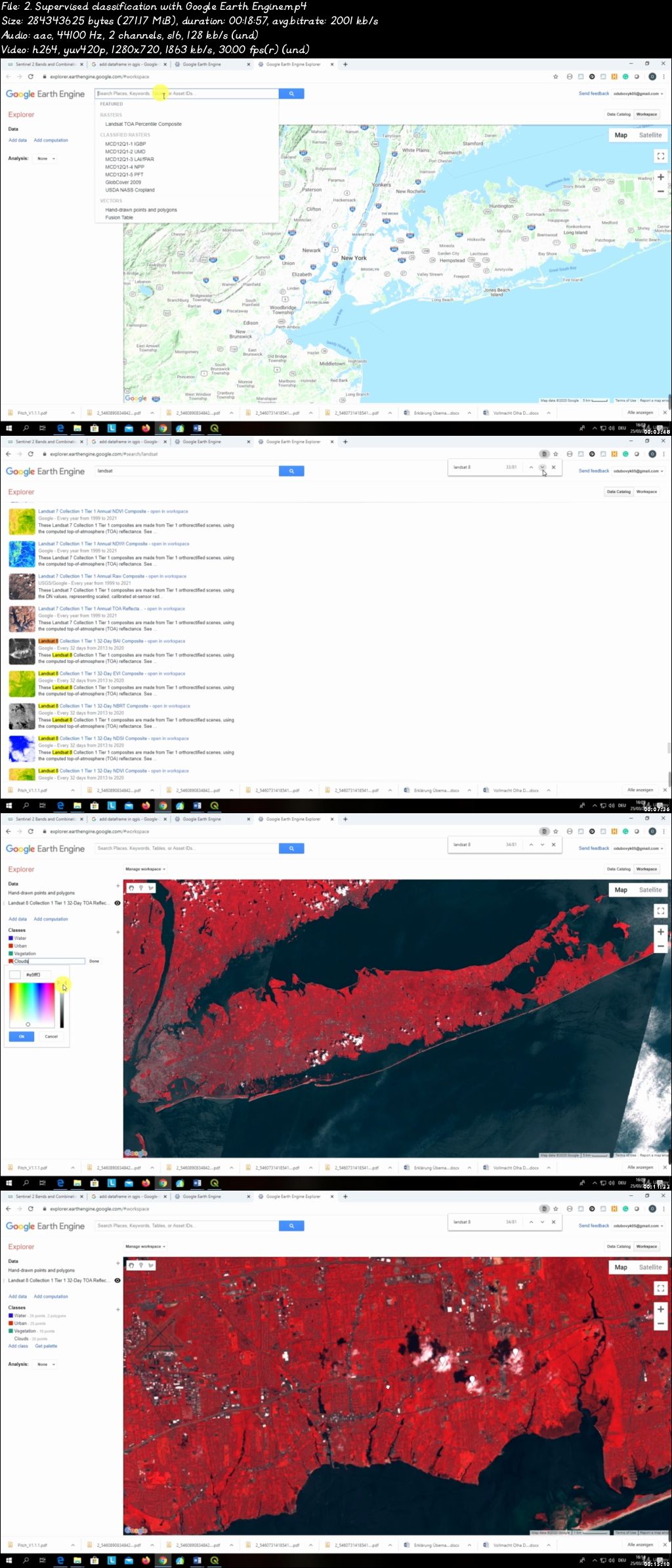
Learn how to apply supervised and unsupervised Machine Learning algorithms in QGIS and Google Earth Engine
Understand what is segmentation, object-based image analysis (OBIA) and predictive modeling in GIS
Learn how to perform image segmentation with Orfeo Toolbox
• Understand the main developments in the field of Artificial Intelligence, deep learning and machine learning as applied to GIS
Requirements
A working computer
Description
This course is designed to equip you with the theoretical and practical knowledge of Machine Learning as applied for geospatial analysis, namely Geographic Information Systems (GIS) and Remote Sensing. By the end of the course, you will feel confident and completely understand the Machine Learning applications in GIS technology and how to use Machine Learning algorithms for various geospatial tasks, such as land use and land cover mapping (classifications) and object-based image analysis (segmentation). This course will also prepare you for using GIS with open source and free software tools.
In the course, you will be able to apply such Machine Learning algorithms as Random Forest, Support Vector Machines and Decision Trees (and others) for classification of satellite imagery. On top of that, you will practice GIS by completing an entire GIS project by exploring the power of Machine Learning, cloud computing and Big Data analysis using Google Erath Engine for any geographic area in the world.
The course is ideal for professionals such as geographers, programmers, social scientists, geologists, and all other experts who need to use maps in their field and would like to learn more about Machine Learning in GIS. If you're planning to undertake a task that requires to use a state of the art Machine Learning algorithms for creating, for instance, land cover and land use maps, this course will give you the confidence you need to understand and solve such geospatial problem.
One important part of the course is the practical exercises. You will be given some precise instructions and datasets to create maps based on Machine Learning algorithms using the QGIS software and Google Earth Engine.
In this course, I include downloadable practical materials that will teach you:
- How to install open source GIS (QGIS, OTB toolbox) software on your computer and correctly configure it
- QGIS software interface including its main components and plug-ins
- Learn how to classify satellite images with different machine learning algorithms (random forest, support vector machines, decision trees and so on) in QGIS
- Learn how to perform image segmentation in QGIS
- Learn how to prepare your first land cover map using the cloud computing Google Earth Engine Platform.
Who this course is for:
Geographers, programmers, geologists, biologists, social scientists, or every other expert who deals with GIS maps in their field
Machine Learning in GIS: Understand the Theory and Practice