Hands-On Geospatial Analysis with QGIS 3.10 and Python

Hands-On Geospatial Analysis with QGIS 3.10 and Python
.MP4, AVC, 1920x1080, 30 fps | English, AAC, 2 Ch | 1h 59m | 5.15 GB
Instructor: Jane Wang
.MP4, AVC, 1920x1080, 30 fps | English, AAC, 2 Ch | 1h 59m | 5.15 GB
Instructor: Jane Wang
Innovative GIS workflow solutions with key complementary technologies
Learn
Carry out and automate geospatial and remote sensing data analysis, research, and visualization
Implement efficient and reproducible workflows for geospatial analysis
Create professional cartographic products that are presentation-ready
Tailor your professional geospatial products to specific needs on the part of clients, Academia, or governmental organizations
Georeferenced datasets, project, and apply styles to spatial layers for mapping and navigational purposes
Query spatial layers for user-defined purposes and answer specific questions
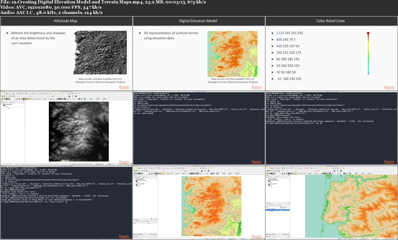
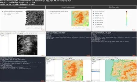
Create stereo maps showing altitude and hillshade and prepare them for professional use
About
Given the increasing amounts of open geospatial and remotely-sensed data and the vast amount of information it provides, GIS is an essential instrument for geographers, engineers, geologists, architects, ecologists, and agronomists who recognize the complex operations required to wrangle, analyze, and visualize their data.
If you're a professional using GIS in your daily work and already have some knowledge of Python, QGIS—aligned with Python—will give you compelling opportunities to streamline workflows and maximize your data analysis and manipulation.
This course will get you up-and-running with geospatial analysis using QGIS 3.10 and Python.
Learn how to use data queries, create a 3D map on a web server, and interact with Python and QGIS. You will learn to distinguish between vector and raster layers; which will give you flexibility when considering data sources and processing methods for problem-solving. While understanding how to process remote sensing data and output terrain maps, and customize and automate geo-processes effectively for your work.
By the end of the course, you will be able to use QGIS 3.10 and Python together to create interactive geospatial maps. The code bundle for this course is available at https://github.com/PacktPublishing/Hands-On-Geospatial-Analysis-with-QGIS-3.10-and-Python
Features
Programmatically and directly interact with geospatial and remote-sensing data to maximize the efficiency and capacities of your workflow
Step-by-step instructions (using straight-forward examples) will take you from scratch to project completion
Take advantage of Python's processing power and its most up-to-date technologies/packages to perform modern geospatial analysis
Hands-On Geospatial Analysis with QGIS 3.10 and Python