

Getting Started with Open Drone Map (ODM)
Getting Started with Open Drone Map (ODM)
Duration: 2h 26m | .MP4 1280x720, 30 fps(r) | AAC, 44100 Hz, 2ch | 2.16 GB
Genre: eLearning | Language: English
Duration: 2h 26m | .MP4 1280x720, 30 fps(r) | AAC, 44100 Hz, 2ch | 2.16 GB
Genre: eLearning | Language: English
Install, Setup and Learn How to use Free Drone Photogrammetry Software
What you'll learn:
Download and install Free and Open Source photogrammetry software
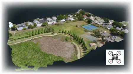
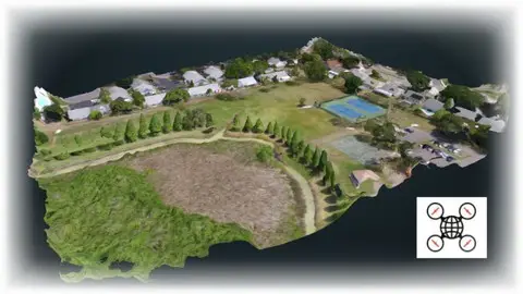
Create 2D data products with your drone (Orthomosaics and DSMs and DTMs)
Create to make 3D data products with your drone (Models and Volume Calculations)
Master Photogrammetry techniques from drone photographs
Requirements:
No experience necessary for installation or analysis. Sample data is available.
Description:
Drones are incredible machines, capable of creating amazingly useful mapping products. By using drone images, one can create detailed maps and models of the earth through a process called Photogrammetry. Essentially, you computer analyzes the same area in multiple images and calculates a 3D model. Because of photogrammetry's usefulness, it is very expensive. However, there is a better way. A great way to get started with this is downloading and installing Open Drone Map, a free and open source software package available to everyone on the web. This course instructs you on how to:
Download and Install Open Drone Map, a free and open source photogrammetry software package
Load in photos that you took with your drone
Create data products such as Orthophotos, Orthmosaics, Digital Surface Models, Digital Terrain Models, 3D models
Take these data products and get them into GIS software for further analysis
Your Instructor has been making digital maps for over 30 years and teaching digital map making techniques at a University in Boston, MA for over 15 years. He has taught countless GIS labs using both ESRI products and, as of late, QGIS software. Around 5 years ago, the drones arrived and have allowed map makers to create high resolution background images of their study areas. As the digital mapping field matures into 3D visualization, drones as data collection machines continue to increase in usefulness.
This course is designed for folks who want to get started in Photogrammetry without having to pony up big bucks for the commercial software. With ODM, you can learn all you want for free. You may graduate up more complicated software at some point if your products start turning a real profit. You may find however that ODM fills all your needs and you'll never have to pay those high costs.
The course comes with instructions on how to get to many sample data sets as well as written instructions for software installation. With this course you have everything you need to get up and running. Now is the time to level up your drone game!
Who this course is for:
Drone pilots who wish to learn 2D and 3D mapping techniques
Those who want to learn drone photogrammetry for free
More Info