

Machine Learning in GIS : Land Use Land Cover Image Analysis
Machine Learning in GIS : Land Use Land Cover Image Analysis
Last updated 11/2024
Duration: 4h 38m | .MP4 1280x720, 30 fps(r) | AAC, 44100 Hz, 2ch | 3.2 GB
Genre: eLearning | Language: English
Last updated 11/2024
Duration: 4h 38m | .MP4 1280x720, 30 fps(r) | AAC, 44100 Hz, 2ch | 3.2 GB
Genre: eLearning | Language: English
Become Expert in advanced Remote Sensing and GIS pixel- and object-based image analysis in Google Earth Engine & QGIS
What you'll learn
- Fully understand advanced methods of Land use and Land Cover (LULC) Mapping in QGIS and Google Earth Engine
- Learn how to perform such advanced methods as object based image analysis (OBIA) and object-based classification using real-world data in QGIS
- Further advanced your skills in the most popular open-source GIS and Remote Sensing software tools (QGIS)
- Learn how to obtain satellite data, apply image pre-processing, create training and validation data for OBIA in QGIS and Google Earth Engine
- Apply advanced Machine Learning image classification algorithms
- Create and download LULC maps for your report
- Explore the power of Google Earth Engine for image analysis
- You'll also have plenty of handy hints and tips will be provided alongside the code to prevent glitches
- You'll have a copy of the labs’ step-by-step manuals used in the course for your reference to use in your analysis.
Requirements
- A vivid interest in working with geospatial data
- Basic knowledge of manipulating spatial (image) data using QGIS
- A working computer with internet connection
- The course will be demonstrated using a QGIS version of Windows PC. Mac and Linux users will have to adapt the instructions to their operating systems.
Description
Advanced Land Use/Land Cover Mapping with Machine Learning
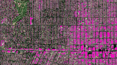
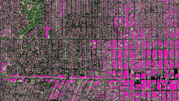
Are you looking to advance your geospatial analysis skills using QGIS? Want to master object-based image analysis and harness the power of Machine Learning algorithms for Land Use and Land Cover (LULC) mapping? This course is designed to take QGIS users from basic geospatial analysis to performing advanced tasks with confidence. Explore object-based image analysis with various data sources and cutting-edge Machine Learning algorithms. Dive into LULC mapping, change detection, and object-based crop type mapping using QGIS and Google Earth Engine.
Course Highlights:
Advanced geospatial analysis using QGIS
Object-based image analysis
Machine Learning algorithms for LULC mapping
Practical exercises with QGIS and Google Earth Engine
Installation and configuration of open-source GIS software
Supervised and unsupervised Machine Learning
Accuracy assessment for geospatial projects
Course Focus:
This advanced course is designed to equip you with practical knowledge in advanced Land Use and Land Cover (LULC) mapping and object-based image analysis. Gain confidence in using Machine Learning algorithms for geospatial tasks and leverage the capabilities of QGIS and Google Earth Engine. Whether you're a geographer, programmer, social scientist, or geologist, this course will enhance your GIS and Remote Sensing skills.
What You'll Learn:
Installing and configuring open-source GIS software (QGIS and Orfeo Toolbox)
Navigating the QGIS software interface, including its main components and plug-ins
Classifying satellite images with different Machine Learning algorithms in QGIS
Collecting training and validation data and performing accuracy assessments
Object-based image analysis and object-based crop type mapping in QGIS
Running supervised and unsupervised Machine Learning Algorithms in Google Earth Engine
Who Should Enroll:
This course is ideal for professionals seeking to advance their geospatial analysis skills, including geographers, programmers, social scientists, geologists, and anyone needing to use LULC maps in their field. Whether you're planning to create land cover and land use maps, tackle geospatial challenges, or explore the cutting-edge LULC techniques, this course provides the skills and confidence you need.
INCLUDED IN THE COURSE:Gain access to all course materials, including data, Java code files, and future resources. Enroll today to take your geospatial analysis to the next level!
Who this course is for:
- Geographers, Programmers, geologists, biologists, social scientists, or every other expert who deals with GIS maps in their field
More Info