

Qgis 3
Qgis 3
Published 9/2024
MP4 | Video: h264, 1920x1080 | Audio: AAC, 44.1 KHz
Language: English | Size: 1.93 GB | Duration: 2h 39m
Published 9/2024
MP4 | Video: h264, 1920x1080 | Audio: AAC, 44.1 KHz
Language: English | Size: 1.93 GB | Duration: 2h 39m
Discover the potential of GIS and learn from scratch. Experience, feel and uncover everything you can achieve with QGIS!
What you'll learn
Create and edit vector layers in QGIS 3, including points, lines, and polygons, and manage their attribute tables efficiently.
Design professional maps using QGIS 3, applying symbology techniques, labeling, and layout composition skills.
Use geoprocessing tools like Buffer, Intersect, Clip, and Merge to perform basic spatial analysis in real GIS projects.
Perform spatial analysis techniques, including interpolation, slope mapping, and watershed delineation using QGIS 3.
Requirements
Basic understanding of GIS concepts (e.g., layers, coordinates, projections).
Elementary knowledge of cartography and map reading.
Discipline and eagerness to learn.
Description
This QGIS 3 course provides a comprehensive, hands-on approach to learning Geographic Information Systems (GIS). It is designed for beginners with basic knowledge of GIS and geodesy concepts, focusing on practical application rather than extensive theory.The course curriculum covers essential QGIS functions and GIS operations. We begin with QGIS installation and interface familiarization, then progress through vector data management, including the creation and manipulation of point, line, and polygon layers. Students will learn to perform table operations, field calculations, and data entry.Map design is a key component, encompassing symbology application, labeling techniques, and the creation of professional layout elements. The course also introduces fundamental geoprocessing tools such as Buffer, Intersect, Clip, and Merge, along with basic spatial analysis techniques including interpolation, slope mapping, and watershed delineation.Each topic is explored through practical exercises, allowing students to immediately apply their learning to real-world scenarios. By the course's conclusion, participants will have developed practical skills in QGIS 3, preparing them for GIS tasks across various fields.This course is ideal for those seeking to quickly gain practical QGIS skills through direct, hands-on learning, without extensive theoretical discussions. Our step-by-step approach ensures you'll gain confidence in using QGIS for diverse mapping and spatial analysis tasks.
Overview
Section 1: Introducción
Lecture 1 Introduction
Lecture 2 Download and installation
Lecture 3 QGIS overview and plugin installation
Section 2: Georeference
Lecture 4 Georeference an image
Lecture 5 Georeferencing an image without control points (optional)
Section 3: Create and edit vector layers
Lecture 6 Creation of vector layers (shapefiles)
Lecture 7 Creation of vector layers (geopackages)
Lecture 8 Working with points
Lecture 9 Working with lines 1
Lecture 10 Working with lines 2
Lecture 11 Working with polygons 1
Lecture 12 Working with polygons 2
Lecture 13 Import UTM coordinates from a table
Section 4: Table management
Lecture 14 Create new fields in tables
Lecture 15 Enter information into table fields
Lecture 16 Calculation of area, perimeter and length
Lecture 17 XY coordinate calculation
Lecture 18 Calculate Geometries in a Second with ArcGeek Calculator
Lecture 19 Operations with tables
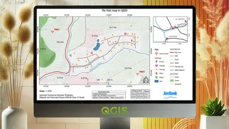
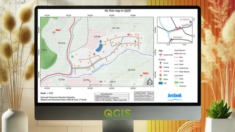
Section 5: Map design
Lecture 20 Symbology of points, lines and polygons
Lecture 21 Import new symbology
Lecture 22 Labels
Lecture 23 3D view (optional)
Lecture 24 General structure of a map
Lecture 25 Title
Lecture 26 Map Body
Lecture 27 Graticules
Lecture 28 North
Lecture 29 Location Map
Lecture 30 Legend
Lecture 31 Scales
Lecture 32 Insert boxes
Lecture 33 Export an image or PDF map
Section 6: Geoprocessing tools
Lecture 34 Areas of influence (Buffer)
Lecture 35 Intersect
Lecture 36 Clip
Lecture 37 Merge
Lecture 38 Dissolve
Lecture 39 Define projection
Lecture 40 Re-project
Section 7: Spatial Analyst
Lecture 41 Importing a Table XY Coordinates
Lecture 42 Interpolation (IDW)
Lecture 43 Slope maps
Lecture 44 Reclassifications
Lecture 45 Contour Lines
Lecture 46 Viewshed
Lecture 47 Map Algebra
Lecture 48 Delineation of a Watershed
Lecture 49 Topographic Profiles
Beginners in GIS looking to gain practical skills in QGIS 3 without extensive theory.,Professionals in fields like urban planning, environmental science, or geography seeking to incorporate GIS into their work.,Students in spatial sciences or related disciplines wanting hands-on experience with a powerful, open-source GIS tool.