

Hyperspectral Satellite Image Classification Using Deep Cnns
Hyperspectral Satellite Image Classification Using Deep Cnns
Published 1/2023
MP4 | Video: h264, 1280x720 | Audio: AAC, 44.1 KHz
Language: English | Size: 1017.01 MB | Duration: 2h 0m
Published 1/2023
MP4 | Video: h264, 1280x720 | Audio: AAC, 44.1 KHz
Language: English | Size: 1017.01 MB | Duration: 2h 0m
Hyperspectral satellite imagery classification Using 1-D, 2-D, 3-D, and Hybrid Convolutional Neural Networks (CNNs)
What you'll learn
Concepts/basics of Convolutional Neural Networks
Visualizing Hyperspectral data in Google Colab
1-Dimensional Convolutional Neural Network development
2-Dimensional Convolutional Neural Network development
3-Dimensional Convolutional Neural Network development
Deep machine learning models training and validation in Google Colab
Developing different advanced machine learning algorithms in Google Colab
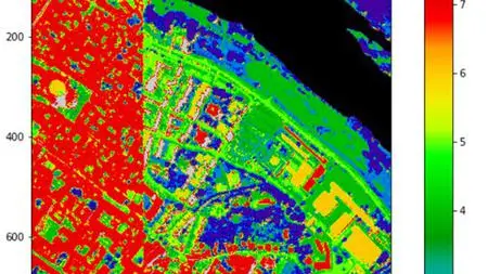
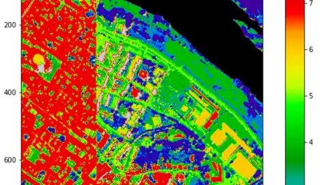
Land Use Land Cover (LULC) mapping with Hyperspectral satellite imagery
Requirements
Basics of Remote Sensing
Basics of Programming
Description
Land cover mapping is a critical aspect of Earth’s surface monitoring and mapping. In this course, Land Use Land Cover Mapping utilizing Hyperspectral satellite imagery is covered. You will learn how to develop 1-Dimensional, 2-Dimensional, 3-Dimensional, and Hybrid Convolutional Neural Networks (CNNs) using Google Colab. The discussed and developed methods can be utilized for different object/feature extraction and mapping (i.e., urban region extraction from high-resolution satellite imagery). Remote sensing is a powerful tool that can be used to identify and classify different land types, assess vegetation conditions, and estimate environmental changes. The use of Google Colab will significantly help you to decrease the issues encountered by software and platforms, such as Anaconda. There is a much lower need for library installation in the Google Colab, resulting in faster and more reliable classification map generation. The validation of the developed models is also covered. In summary, remote sensing and GIS technologies are widely used for land cover mapping. They provide accurate and timely information that is critical for monitoring and managing natural resources.Highlights:1. Learn the concepts of Convolutional Neural Networks (CNNs)2. Learn how to develop CNN models3. Learn how to classify Hyperspectral satellite imagery using python programming language4. Learn how to validate a CNN model5. Learn to read and import your data from your Google Drive into Google Colab6. Map Land use land covers utilizing Hyperspectral satellite data with different variations of CNN models7. Learn how to validate a machine-learning model
Overview
Section 1: Introduction
Lecture 1 Introduction
Lecture 2 Required Concepts
Lecture 3 Basics of Convolutional Neural Networks (CNNs)
Section 2: 1-Dimensional CNNs
Lecture 4 Load Hyperspectral data
Lecture 5 1-Dimensional CNN development
Lecture 6 1-D CNN model Training
Lecture 7 Hyperspectral satellite imagery classification using a 1-D CNN model
Lecture 8 Points
Section 3: 2-Dimensional CNNs
Lecture 9 Load Hyperspectral satellite data
Lecture 10 2-D CNN model development
Lecture 11 2-D CNN model training
Lecture 12 Hyperspectral satellite imagery classification utilizing a 2-D CNN model
Section 4: 3-Dimensional CNNs
Lecture 13 Load Hyperspectral satellite imagery
Lecture 14 3-D CNN development
Lecture 15 3-D CNN model training
Lecture 16 3-D CNN model validation
Lecture 17 Hyperspectral satellite imagery classifiaction-1
Lecture 18 Hyperspectral satellite imagery classifiaction-2
Lecture 19 Hybrid CNN development
Students and professionals interested in writing and publishing high-quality papers,Remote sensing engineers,GIS engineers,Govt sector agriculture scientists,Master students of GIS and Remote Sensing,Data scientists interested in Remote Sensing image processing,Ph.D. students of Data science, GIS, and Remote Sensing