

Gnss Gps Imu Ins Sensors - For Adas And Autonomous Vehicles

Gnss Gps Imu Ins Sensors - For Adas And Autonomous Vehicles
Published 2/2023
MP4 | Video: h264, 1280x720 | Audio: AAC, 44.1 KHz
Language: English | Size: 4.99 GB | Duration: 10h 58m
Published 2/2023
MP4 | Video: h264, 1280x720 | Audio: AAC, 44.1 KHz
Language: English | Size: 4.99 GB | Duration: 10h 58m
D-GNSS, DGPS, RTK, PPP, SBAS, GBAS, AHRS, Accelerometer, Gyroscope, Magnetometer, Python, fusion, Raspberry-pi 4
What you'll learn
GNSS (Global Navigation Satellite Systems) in detail together with its role in ADAS and Autonomous vehicle test and development
Hands on with GPS sensor and raspberry pi 4 using python to receive real-time GPS data
Exploring various applications of GNSS based systems in automotive and non-automotive industry
Hands on with 3 axis accelerometer and 3 axis gyroscope with raspberry pi 4 and python
GNSS based correction methods - Differential GNSS, DGPS, SBAS, GBAS, RTK, PPP in detail
Foundation of accelerometer, gyroscope and magnetometer with mathematical insights
Understanding IMU - Inertial Measurement Unit and its importance in INS (Inertial Navigation System)
Getting deeper (only theoretical) into GNSS and INS based fusion using Kalman filter based approaches.
Details of AHRS (Attitude and Heading Reference System) and Dual GNSS / INS system
Multiple case-studies covering various fusion techniques (theoritical) and applications with GNSS and INS
Additional reference material in form of research litertures and web-links
By the end of this course, you will be confident to use GNSS/INS based sensor system for your ADAS / Autonomous vehicle test and validation in your work.
Requirements
Computer with internet connection
Motivation to study and learn new technology
(optional) low cost raspberry pi and GPS, IMU sensor for hands on practice.
Description
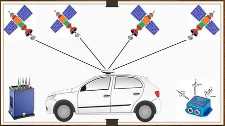
Sensors are an indispensable part of Advanced Driver Assistance Systems (ADAS) and Autonomous Driving (AD) Technology. Sensors - like cameras, radar, lidar and ultrasonic are well known to all. These sensors are used to do external environmental perception around the vehicle and in some cases also to do in-vehicle perception. GNSS (Global Navigation Satellite System), GPS (Global Position System) together with INS (Inertial Navigation System) are used to find the location of the ego vehicle itself. These sensors are used for multiple applications in the ADAS and the AD industry. These applications include but are not limited to:1. Localization of vehicles on the road2. To generate ground truth data for sensor perception (radar, lidar, camera) validation3. To generate ground truth data for sensor fusion validation4. For validation of various ADAS functions in the deterministic test sites5. For using the GNSS/GPS highly accurate time - as a reference clock to synchronize (using NTP, PTP or gPTP) multi-sensor systems for algorithm development.6. In V2X (Vehicle to Other) and V2V (Vehicle to Vehicle) applications.and many more…….GNSS/GPS + INS sensors also have multiple applications in various non-automotive fields like Navigation with mobile phones and cars, in Rail transport - to track locomotives, in aviation - for aircraft navigation from departure to landing, in marine - to track and navigate ships, in Port Automation, Precise Agriculture, Surface mining, Surveying, Drones, Smart Infrastructure application, etcAs GPS/GNSS alone cannot provide centimetre-level accuracy (which is necessary for ADAS and AD applications), various add-on technologies are used1. DGNSS (Differential GNSS)2. DGPS (Differential GPS)3. SBAS (Satellite Based Augmentation System)4. GBAS (Ground Based Augmentation System)5. RTK (Real Time Kinematic)6. PPP (Point Precision Positioning)Moreover, Inertial Navigation Sensors - Accelerometer, Gyroscope and Magnetometer are also used with GPS /GNSS for better localization and accurate measurement, especially in situations where a GNSS signal is unavailable. This includes 1. Inertial Navigation systems (INS), 2. GNSS-aided INS system, 3. AHRS (Attitude and Heading Reference System), 4. Dual GNSS (or GNSS compass) -aided INS system.In this course, you will learn all of the above-stated technologies so that you will be able to use them in your work and/or projects. In addition, hands-on practice in measuring real-time GPS and IMU data using low-cost sensors with raspberry pi 4 and python3 is included.Through this complete course which consists of 9+ hours of videos, you will learnBasics of ADAS (Advanced Driver Assistance systems) with some examplesBasics of AD (Autonomous Driving) together with SAE levels of automationBrief understanding of various sensors like Radar, lidar, camera, and ultrasonic used in ADAS and AD.Lots of applications covering the usage of GNSS + INS sensors in ADAS and AD industry as well as non-automotive domainsVarious GNSS + INS devices available in the market (ranging from high cost to low cost)Deeply understanding GNSS technology, signal processing, pseudo-range calculation, trilateration, GNSS errors, different ways to overcome these errorsVarious types of coordinate systems and frames used in GNSS technologyWhat are latitude and longitude? Different ways to represent them and their inter-conversionsNMEA-0183 message structures for GPS measurementReal-time GPS measurement using a low-cost GPS device, raspberry pi 4 and python 3.Various Differential correction methods - DGNSS, DGPS, SBAS, GBAS, RTK, PPPUnderstanding IMU (Inertial Measurement Unit) and then deep dive into the working of accelerometer, gyroscope and magnetometerReal-time IMU measurement using a low-cost IMU with raspberry pi 4 and python 3Understanding INS (Inertial Navigation System) using a case study of pedestrian dead reckoning using INSDeep dive into AHRS (Attitude and Heading reference system), GNSS-aided INS technology and Dual GNSS-aided INS technology.Further case studies were taken from research papers to understand applications of GNSS and INS (along with other sensors) in ADAS, AD and robotics.Note: This course focuses more on understanding the concepts and provides insights into various technologies in this domain hence programming is intentionally kept to a minimum. Disclaimer: All the reference videos taken from various sources are only used for educational purposes and there is no intention to infringe copyright.
Overview
Section 1: Introduction
Lecture 1 Introduction
Section 2: Why GNSS GPS IMU INS RTK in ADAS and Autonomous Driving ?
Lecture 2 Intro
Lecture 3 ADAS and Autonomous Driving
Lecture 4 Sensors in ADAS and Autonomous vehicles
Lecture 5 GNSS applications in ADAS and Autonomous Driving - Part 1
Lecture 6 GNSS applications in ADAS and Autonomous Driving - Part 2
Lecture 7 GNSS applications - other domains
Lecture 8 GNSS, INS sensors available in market
Lecture 9 Some Terms and definitions
Lecture 10 Outro
Section 3: GNSS (Global Navigation Satellite Systems)
Lecture 11 Intro
Lecture 12 What is GNSS ?
Lecture 13 GNSS - Segments
Lecture 14 GNSS - satellites and signal generation
Lecture 15 GNSS - signal propagation, reception and processing
Lecture 16 GNSS - Position calculation using trilateration
Lecture 17 GNSS Errors
Lecture 18 GNSS - Techniques to resolve errors
Lecture 19 Multi frequency and multi constellation receivers
Lecture 20 GNSS coordinate system
Lecture 21 Different representations of Latitude and longitude
Lecture 22 NMEA-0183 GNSS/GPS message standard
Lecture 23 Concept - Real time GPS measurement using raspberry pi 4
Lecture 24 Implementation - Real time GPS measurement using raspberry pi 4
Lecture 25 Outro
Section 4: GNSS - Differential correction based systems
Lecture 26 Intro
Lecture 27 DGNSS - Differential GNSS and DGPS
Lecture 28 SBAS - Satellite based Augmentation Systems
Lecture 29 GBAS - Ground based Augmentation Systems
Lecture 30 Code phased ranging and carrier phase ranging
Lecture 31 RTK - Real Time Kinetic
Lecture 32 PPP - Precise Point Positioning
Lecture 33 Comparing various correction methods
Lecture 34 Outro
Section 5: IMU (Inertial Measurement Unit)
Lecture 35 Intro
Lecture 36 Insights of IMU
Lecture 37 Concept of Accelerometer - part 1
Lecture 38 Concept of Accelerometer - part 2
Lecture 39 Concept of Gyroscope - part 1
Lecture 40 Concept of Gyroscope - part 2
Lecture 41 Concept of Magnetometer
Lecture 42 Concept - Interfacing and using IMU with raspberry pi 4
Lecture 43 Implementation - Interfacing and using IMU with raspberry pi 4
Lecture 44 Outro
Section 6: INS + GNSS, AHRS
Lecture 45 Intro
Lecture 46 INS (Inertial Navigation System)
Lecture 47 AHRS (Attitude and Heading Reference System)
Lecture 48 GNSS aided INS - Part 1
Lecture 49 GNSS aided INS - Part 2
Lecture 50 GNSS aided INS - part 3
Lecture 51 GNSS Compass/INS or Dual GNSS/INS
Lecture 52 Outro
Section 7: Case studies of GNSS and INS based systems
Lecture 53 Case study 1
Lecture 54 Case study 2
Lecture 55 Case study 3
Lecture 56 Case study 4
Section 8: Wrap Up
Lecture 57 Congratulations
Lecture 58 Reference Material for further learning
Lecture 59 My other courses
Anyone interested to learn and understand GNSS INS based measurement technology use for position, speed, time and heading estimation,People involved in ADAS and Autonomous vehicle development - it is highly recommended to do this course