Arcswat Model With Arcgis - Run For Any Study Area - Gis
Arcswat Model With Arcgis - Run For Any Study Area - Gis
Last updated 2/2023
MP4 | Video: h264, 1280x720 | Audio: AAC, 44.1 KHz
Language: English | Size: 6.45 GB | Duration: 6h 38m
Last updated 2/2023
MP4 | Video: h264, 1280x720 | Audio: AAC, 44.1 KHz
Language: English | Size: 6.45 GB | Duration: 6h 38m
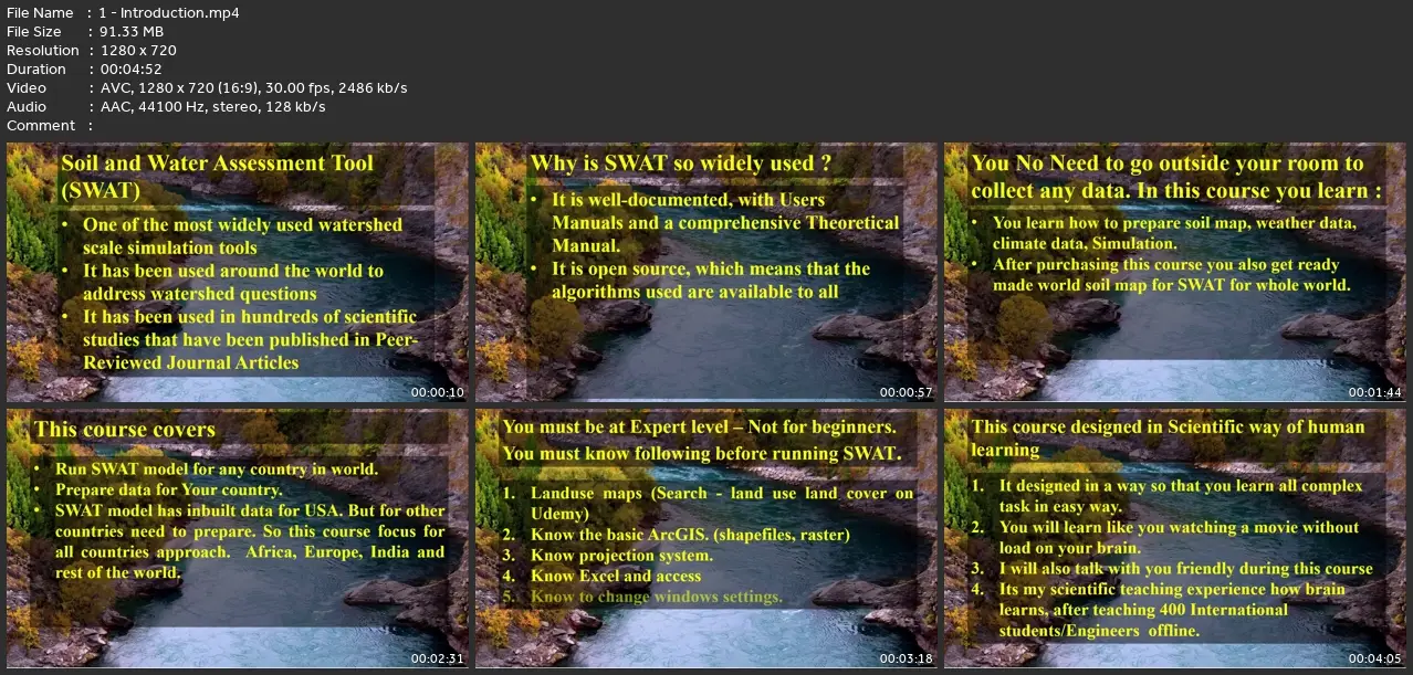
Watershed Simulation using ArcSWAT. Get Discharge, Rainfall‐Runoff Modeling of Ungauged Catchments. This is advance GIS
What you'll learn
Discharge in Cubic meter Per Second at Watershed outlet, Daily Monthly and yearly
Watershed and Sub-watershed delineation using SWAT
Configure SWAT model for any Area in World
Groundwater Recharge
Sediment at outlet (Soil Erosion)
Water Yield
Water Quality
Simulation of Daily Data
Data preparation for SWAT
Updating SWAT Database
Understanding advance task of Simulation
Working with daily data and working without data
Configure Data set for India
Evaporation and Evapotranspiration
Watershed Simulation
Successfully run The SWAT Model
Preparation of Soil Map of Any country
Mosaic of DEM
R programming applications for weather data
Requirements
This is Advance level course of GIS. So You must know Basic of GIS .
You must have Landuse of your Study area
Having some knowledge about excel.
Little knowledge about Hydrology.
Must Know ArcGIS and Erdas
ArcGIS 10.0 - 10.7
Just little programming experience
Description
ArcSWAT in the most widely used watershed simulation model in GIS. Most of the papers were accepted in peer review Journals that used SWAT model. This model has inbuilt data for the USA. But it does not have data for other countries. So we need to configure this model for non-us locations. Even you will be able to run this model for the USA after this course because we configure this model for the whole world. Only India has a different process to configure this model and a different for other countries. So I will cover all methods and prepare dataset, simulate two time this model for you one for India and one for any other country in the world. I will Start from scratch. Show you the configuration of data , data download, sources, modify data set, theoretical aspect, Practical . even after the simulation, This course will represent you how to illustrate results in Excel. So this course will cover the entire SWAT model. Advanced applications of R programming for weather data are also covered. You only need knowledge of two things, Landuse generation and ArcGIS Just basic not advanced. The rest of all you leave on me I will cover. You just need Basic GIS. The only thing is that you must have land use. After Enroll to this course you will get ready made soil map for SWAT for world also. You will also learn how to make it for SWAT. You will learn to setup all weather and climate data for swat. I hope you will publish good papers after learning this. You can also use this course for short term training course in your University. Just need to play on screen. Everything in this course is 90% practical. This course is advance course of GIS. Applicable to ArcGIS 10.0 to 10.7Hardware Requirement: For small study area less than 10,000km/sq no Problem. But larger than this you must have a high-performance PC.
Who this course is for:
Water Resource Engineers,Student at WRDM,DAM Engineers,Water Resource Development Scientists,Ph.D Student Working on ArcSWAT Model and GIS,GIS Water Resource Experts,Urban Planners,Master Student of Remote Sensing,Civil Engineers,Country Planners,Irrigation Engineers,Research Scientist,Earth Science Researchers
Arcswat Model With Arcgis - Run For Any Study Area - Gis