


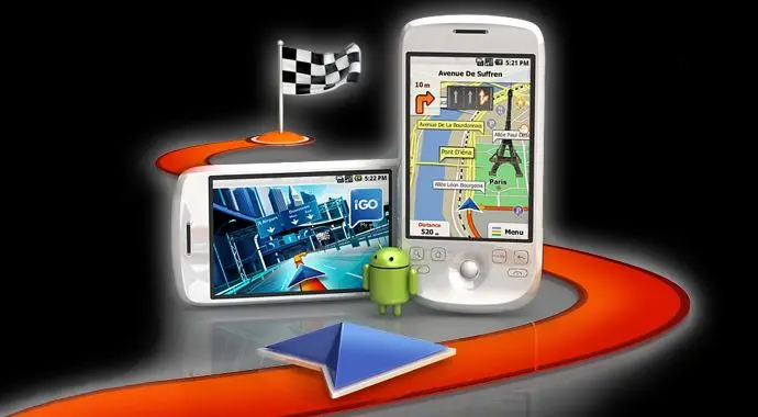
iGO My Way (Android) + Europe maps (2010)
iGO My Way (Android) + Europe maps (2010) | 2.52 Gb
The iGO My way GPS navigation software helps you reach your destinations quicker and easier than ever before. Whether you use it in heavy metropolitan traffic or out in the countryside, iGO My way will always show you the right way. It only takes one minute, and iGO My way is ready to cruise!
Features and Functions
Europe R3 2010.12 TeleAtlas & Europe 2010.12 Teleatlas Premium POI & Europe 2010.12 Teleatlas files (.ftr) (information for trucks)
Europe R3 2010.12 TeleAtlas & Europe 2010.12 Teleatlas Premium POI & Europe 2010.12 Teleatlas files (.ftr) (information for trucks)
iGO My Way (Android) + Europe maps (2010)

Release date: 2011, Data date: 2010.12 Teleatlas
Version: R3
Maker: NavNGo
Detailed Europe maps and updated Premium POI iGO8 (for R3 version), iGO Amigo and iGO Primo navigation programmes.
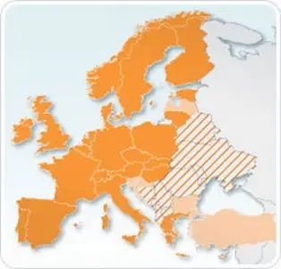
Countries: Belgium, Netherlands, Luxembourg, Germany, Austria, Liechtenstein, Switzerland, Andorra, Spain, Gibraltar, Portugal, Norway, Sweden, Denmark, Finland, United Kingdom, Ireland, Italy, San Marino, Vatican City, France, Monaco, Malta, Poland, Slovakia, Czech Republic, Hungary, Estonia, Lithuania, Latvia, Greece, Slovenia, Turkey, Bulgaria, Croatia, Albania, Former Yugoslav Republic Of Macedonia, Belarus, Bosnia Herzegovina, Moldova, Montenegro, Romania, Serbia, Ukraine
Road coverage: 9 913 345 km >99%: Andorra, Austria, Liechtenstein, Belgium, Denmark, Finland, France, Monaco, Gibraltar, Germany, Ireland, Italy, San Marino, Vatican City, Luxembourg, Malta, Netherlands, Norway, Portugal, Spain, Sweden, Switzerland, United Kingdom, Poland, Hungary, Czech Republic, Slovakia, Lithuania, Estonia, Slovenia, Greece, 63%: Latvia, 67%: Turkey, 53%: Bulgaria, 59%: Croatia, 13%: Romania
House number coverage: yes, except for Andorra, Albania, Bosnia Herzegovina, Former Yugoslav Republic Of Macedonia, Moldova, Montenegro, and Serbia
Postal codes: yes except for Albania, Belarus, Bosnia Herzegovina, Bulgaria, Croatia, Former Yugoslav Republic Of Macedonia, Montenegro, Romania, Serbia, Slovakia, Turkey, and Ukraine
Signpost and lane information*: yes, except for Gibraltar, San Marino, and Vatican City
* Please note that not all software versions display signposts and lane information.
.ftr files ONLY for iGO Primo ir Becker Truck navigation programmes
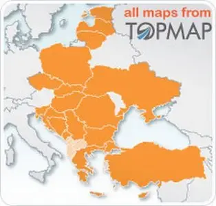
Eastern Europe R3 2010.10 TopMap edition (iGO 8 maps)
iGO My Way (Android) + Europe maps (2010)

Release date: 2010.12, Data date: 2010.10 Topmap and othe local manufacturers
Version: R3
Maker: NavNGo
Detailed eastern Europe maps and updated POI iGO8 (R3 version), for iGO Primo navigation programme. Also is a newest files of Bulgaria, Turkey, Ukraine .3dc building ir Eastern Europe .hnr
Countries: Hungary, Romania, Slovakia, Czech Republic, Poland, Bulgaria, Slovenia, Serbia, Croatia, Bosnia Herzegovina, Montenegro, Ukraine, Greece, Cyprus, Turkey, Latvia, Lithuania, Estonia Albania and Former Yugoslav Republic Of MacedoniaFor every screen resolution we creating separate instalation .apk file.
Road coverage: 3 064 674 km >99.5%: Hungary, Czech Republic, Slovakia, Slovenia, Estonia, Latvia, Greece and Cyprus, 99%: Poland, 90%: Montenegro, Lithuania,85%: Serbia, 83%: Bulgaria, 76%: Romania, 70%: Turkey, 69%: Croatia, 56%: Former Yugoslav Republic Of Macedonia, 43%: Ukraine, 37%: Bosnia Herzegovina, 28%: Albania
House number coverage: >99.5%: Hungary, Czech Republic and Slovenia, 95%: Estonia, 80%: Latvia, 75%: Lithuania, 66%: Croatia, 61%: Greece, 61%: Poland, 59%: Turkey, 56%: Romania, 53%: Bulgaria, 51%: Cyprus, 42%: Serbia, 40%: Slovakia, Ukraine, 10%: Bosnia Herzegovina, n/a: Montenegro, Albania, Former Yugoslav Republic Of Macedonia
Postal codes: yes
Signpost and lane information:
* yes: Hungary, Bulgaria, Croatia, Czech Republic, Estonia, Latvia, Lithuania, Poland, Romania, Serbia, Slovakia, Slovenia and Turkey
Points of interest: 1 046 987
* Please note that not all software versions display signposts and lane information.
Main resolution for iGO programme is 320x480
Representative - LG GT540, LG GW620, HTC Hero, HTC Dream, HTC Magic, Samsung GT-I5700 …
Instalation file - iGOMyWay_8.4.2.139242_JMX.apk – 11.3MB
Resolution – 240x320
Representative – HTC Tattoo, HTC Wildfire ..
Instalation file - iGOMyWay_8.4.2.139242_tattoo_v3.apk – 10.8MB or igomyway.8.4.2.139242_320X240_qvga.apk – 10.0MB
Resolution – 480x800
Representative – Acer Liquid, HTC Desire, Samsung GT-i9000 Galaxy ..
Instalation file - iGOMyWay_8.4.2.139242_JMX_tangbohu_jnorbi.apk – 13.8MB or iGOMyWay_8.4.2.139242_800x480_MotoGIS_V2.0b.apk -14.7MB
Resolution – 480x854
Representative – Motorolla Milestone, SE XPERIA X10 …
Instalation file (MotoNav version) - Motonav_JM_PPCW.apk – 11MB
One more file for 240x400 resolution - iGOMyWay_8.4.2.139242_SMG_i5800_test.apk - 13.2MB
Instalation:
In the SD card must be iGO folder (or – Motonav if resolution 480x854) with folders inside: License (Android_Amigo_WW@1001_JM-PPCW.lic) and Content.
Just make copy iGO folder from "iGO folder for SD card_Android" folder.
If you have Samsung Galaxy S then iGO folder must be copied to internal memory.
Close to the iGO folder make copy of iGO My Way instalation file and run him with File Manager.
DOWNLOAD iGO My way file (139mb)
HotFile | FileFactory | FileSonic
DOWNLOAD Maps
Europe R3 2010.12 TeleAtlas (1.44Gb) & Europe 2010.12 Teleatlas Premium POI (330Mb)
Parts of archive (hotfile):
01 | 02 | 03 | 04 | 05 | 06 | 07 | 08 | 09 | 10 | 11
POI:
01 | 02 | 03
Parts of archive (filefactory):
01 | 02 | 03 | 04 | 05 | 06 | 07 | 08 | 09 | 10 | 11
POI:
01 | 02 | 03
Parts of archive (filesonic):
01 | 02 | 03 | 04 | 05 | 06 | 07 | 08 | 09 | 10 | 11
POI:
01 | 02 | 03
Europe 2010.12 Teleatlas files (.ftr) (for trucks) (141mb)
HotFile | FileFactory | FileSonic
Eastern Europe R3 2010.10 TopMap edition (498mb)
Parts of archive (hotfile):
01 | 02 | 03 | 04
Parts of archive (filefactory):
01 | 02 | 03 | 04
Parts of archive (filesonic):
01 | 02 | 03 | 04
Password: password
No Mirrors below, please!
HotFile | FileFactory | FileSonic
DOWNLOAD Maps
Europe R3 2010.12 TeleAtlas (1.44Gb) & Europe 2010.12 Teleatlas Premium POI (330Mb)
Parts of archive (hotfile):
01 | 02 | 03 | 04 | 05 | 06 | 07 | 08 | 09 | 10 | 11
POI:
01 | 02 | 03
Parts of archive (filefactory):
01 | 02 | 03 | 04 | 05 | 06 | 07 | 08 | 09 | 10 | 11
POI:
01 | 02 | 03
Parts of archive (filesonic):
01 | 02 | 03 | 04 | 05 | 06 | 07 | 08 | 09 | 10 | 11
POI:
01 | 02 | 03
Europe 2010.12 Teleatlas files (.ftr) (for trucks) (141mb)
HotFile | FileFactory | FileSonic
Eastern Europe R3 2010.10 TopMap edition (498mb)
Parts of archive (hotfile):
01 | 02 | 03 | 04
Parts of archive (filefactory):
01 | 02 | 03 | 04
Parts of archive (filesonic):
01 | 02 | 03 | 04
Password: password
No Mirrors below, please!