

iTwin Capture Manage and Extract 2024 (24.00.01.01)

iTwin Capture Manage and Extract 2024 (24.00.01.01) | 444.8 mb
Orbit, now part of Bentley Systems, is pleased to announce the availability of iTwin Capture Manage & Extract 2024 (24.00.01.01) is combines the power of Orbit 3DM Content Manager and Orbit 3DM Feature Extraction Pro into a single desktop product.
Spatial Attributes for Asset Resources
- The Project-based extensions Pole Analysis, Traffic Sign Anaylsis will now write additional Spatial Attributes files.
Assets and Asset Resources
- Auxilliary Project-based analysis results can be imported into Asset Resources. This includes, OPS, Spatial Attributes, and Images.
- Imported Asset Resources will check for FD_ID when importing Project-based results.
- Asset Resources that were previously exported to SHP can now be successfully reimported as Asset Resources.
- Asset Resources have a Progress Bar, Cancel button, and Stop button within the extension if measured with Semi-automatic measurements.
- Box Models can be imported into Asset Resources as data Point datatype.
Linear Reference Systems
- Linear Reference Systems can now be added and updated via Workspace > Linear Reference Systems. This menu gives more visibility on the compenents of the added LRS. Visible values include:
. Name
. Query attribute
. Offset
. #Objects
. CRS
. Status Icon
- Components of the LRS are now within a foldable window in the Measure sidebar.
- Linear Reference Systems can be now managed from Local AppData.
- Linear Reference Systems will be searched Globally on only the selected LRS.
- Linear Reference outputs provide additional results in the measure sidebar. New measure ID's include “ME LRef ID”.
- Via Map 3D Navigation, LRS can be locked on.
Manage Mapping Resources
- A tooltip has been added in the lower left corner to indicate whether a processed or original image has been opened within Mapping Image Views.
- Mapping runs can have video added via the Import Run and Edit Procedure.
- If mapping runs have Video data, a column “Additional Data” will be in the Resource Catalog.
- A new feature “Open Video” is available within the Mapping Tab if data contains video files.
- Getting Alternative Images can now be toggled within the Mapping, Oblique, Terrestrial, and Aerial Mapping Preferences.
- A refined envelope can now be automatically made during the creation of a mapping resource. Additoinally Refined Enveloped can be defined with the resource within a Mapping Run's omr via “refined.envelope.resources”. Values which can be set include:
. Panorama
. Planar
. PointCloud
. TrajectorySimplified
. Mesh
. Ortho
Manage Generic Resources
- The content type BOX is is not set on the Model Level instead of Dataset Level.
- When Managing Image Annotations, the additional relevant data from ContextScene files are now written into the “image_pixel.ini” files.
- Antenna measurements are moved to the Point Measurement Tools.
- iTwin RDV annotations can now be converted into multi-model GIS Vector datasets.
- Saved measurement values can now stay visible when vector files are not selected.
- The CreateFootprint.bat file is is now a public .bat file and is added in this release.
- Line and Area Vector Layers can be copied/duplicated into Point datasets via 2D Edit Tools.
- System Values and Values Derived from Formulas will now be copied into new dataset when using Duplicate Object.
- OTM files will now search for content-type, if the web service capabilities describe the content type.
- OTM authentication can now be supported in all OTM usable formats.
Reality Management
- An “ID” column has been added to the Reality Management Tab. This can be also be copied to clipboard.
- ContextScene files included in Mapping Runs will now upload to the cloud.
- The display of relevant information of resrources with the Resource Catalog has been updated. This includes new and update updated columns, new fixed width, and a horizontal sidebar.
- A Multi-Model source file can now be converted into SHP files.
Usabilities
- Delivery exports are disabled when selecting Mapping runs of different disciplines. Tooltips have been added to notify this is no longer possible.
- Procedures are now automatically closed when opening a new procedure.
- The Reference Map will now initialize CRS when using the Georeference Tool, Slice View, Clash Detection, and Point Cloud Selection.
- OBJs without ORD files will optimize more quickly.
- The Tool “ContextScene to OVF” has not been integrated as part of Convert Data.
- Fixed a previous window popup opening when reopening Startup Configurations.
- Simultaneously Adding and removing multiple resources is now possible via the Resource Catalog.
- ORD will not be overwritten automatically if source data type changes during convert.
- System display units can now be seen in the Extension and Tools sidebars.
- After pinning and unpinning, the previously used extension will open.
- Clearer feedback is indicated when opening and incorrect or corrupt resource.
- An “Open Logfile” button is added from a Error Popup window.
- Outputs of Project-base extensions can be more quickly opened via Drag-and-drop of the project configuration file.
- Convert Imagery will skip any corrupt images, but continue optimization. Additionally, the error button will open to consult the logfile.
- Mapping runs with multiple cameras will have update web readiness tooltips if not all cameras have optimized imagery.
- During the Web Readiness Check, all error and warnings will be displayed if a resource has more than one issue.
- Fallback measurement options are now highlighted in blue when Selected in the 3D Hover and Measurement panel.
- The Mask Creator now has a “Zoom to Image Extent” button.
- The Import and Upload Tool no longer has the possibility to delete objects.
- Spacing in the Object inspector and default visibility of its tools have been updated to more relevant data.
- The 2D Edit sidebar block Appearances has been consolidated into Preferences options. Additionally some items have been renamed for naming consistency, and relevant 2D Edit options are more easily accessed via Preferences.
- When using Shape Creator, Mask Creator, and Image Annotation Editor, it is no longer possible to drag-and-drop files when the “New or Edit” mode is on.
Layout
- The Import and Upload Tool now has the “Add Resource” button in the Main toolbar.
Tag
- The Catenary Detector has naming updated to better reflect the Catenary Measurements.
- Tooltips and Buttons within the CRS panel have been renamed and updated for naming consistency.
- Tooltips have been updated to better reflect when opening file location or directory.
- Tooltips for Web Ready Data have been updated to not be branded.
- Uploading to Reality Management will have a Fallback error popup if a user is selecting file types different that file selection type.
- Mnemonic keystroke have been added with mouse scroll wheel to move forward and backward along locked a Primary Resource or LRS.
- The origin of data can now be seen within the Dataset Properties > Inspect window.
Bug Fixes
- ODB resources can now be removed via the “-” icon from the dataset list.
- Filtered Measured buttons are now correctly showing in the Verify Asset Objects if Measure Functions are adjusted.
- Fixed an unnecessary save button from occasionally appearing in the dataset window.
- The Analysis engine will now have installation verification checks and results saved in the preferences.ini.
- The outline from Tree Detection is now created when set within the Tree Detection Parameter.
- LRef values are now properly updated when switching from Map3D to Map2D.
- Class names on classified point clouds now correctly retain the the same name upon classification.
- Lines created from Semi-automatic measurements like Multiple Ridges will now have new Object IDs when split with 2D Edit tools.
- Snapping vertices on Map2D are now rendered if OpenStreetMap is visible.
- Fixed a bug where ContextScene annotations were imported into the wrong target resource.
- Exports from OVF to GeoJson will now successfully complete.
- Fixed an issue with WFS Axis being reversed in 1.1.0 or higher
- Fixed an issue with WFS to always request features with the default or “other” SRS within the capabilities document.
- Fixed and issue to load WFS with GetFeatures not implemented to spec.
iTwin Capture Manage and Extract 2024 (24.00.01.01)

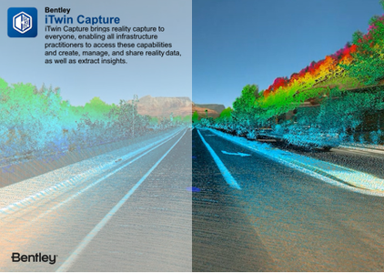
Twin Capture, for capturing, analyzing, and sharing reality data, enables users to easily create engineering-ready, high resolution 3D models of infrastructure assets using drone video and survey imagery from any digital camera, scanner, or mobile mapping device. Infrastructure digital twins of any existing assets can accordingly start with reality modeling, rather than requiring a BIM model. iTwin Capture offers the highest-fidelity and most versatile means of capturing reality to serve as the digital context for surveying, design, monitoring, and inspection processes.
iTwin Capture Manage & Extract combines advanced reality data management and powerful feature extraction into a single user-friendly desktop application. iTwin Capture Manage & Extract gives you a full 3D 360-degree view of the world by enabling the real-time fusion of various reality data of any size from any system. iTwin Capture Manage & Extract combines the power of Orbit 3DM Content Manager and Orbit 3DM Feature Extraction Pro into a single desktop product.
Delete Point Cloud by iTwin Capture Manage & Extract
October 18th 2019, Orbit GT signed an agreement to become part of Bentley Systems, and joined Bentley’s new Digital Cities business unit led by Mr Robert Mankowski, which is a perfect place for team and technology to continue our work and engage in even larger challenges that the future world will bring to us.
Bentley Systems is a software development company that supports the professional needs of those responsible for creating and managing the world’s infrastructure.
Owner: Orbit (now part of Bentley Systems)
Product Name: iTwin Capture Manage & Extract
Version: 2024 (24.00.01.01)
Supported Architectures: x64
Website Home Page : www.bentley.com
Languages Supported: english
System Requirements: Windows *
Size: 444.8 mb
iTwin Capture Manage and Extract 2024 (24.00.01.01)

Please visit my blog
Added by 3% of the overall size of the archive of information for the restoration
No mirrors please

![iTwin Capture Manage and Extract 2024 (24.00.01.01)]()
Added by 3% of the overall size of the archive of information for the restoration
No mirrors please
iTwin Capture Manage and Extract 2024 (24.00.01.01)
