

Viking Informatics GpsMap v2.50 S60v3

Viking Informatics GpsMap v2.50 S60v3 | SymbianOS | 350KB
Use your own maps for displaying your position on a map, even without GPS. Waypoints, compass view also supported.
FEATURES:
displays location and waypoints on a map, displays compass or latitude/longitude;
add, remove maps;
add, remove a waypoint by typing its coordinates or marking its location on map;
calibrate maps manually or importing from OziExplorer;
phone standby mode can be switched off;
GPS device identifier may be stored (no need to set it up);
connection to the GPS device is restored automatically;
NEW: position source could be selected (Network based positioning also usable);
NEW: correct mapping even for different projection systems.
STARTUP:
(Optional) Start the GPS device;
Start the application, select the desired device (only at the first run, you can change it later in Settings);
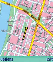
Current position displayed
DISPLAY:
Text: current position in WSG 84 format, speed, direction, altitude is displayed (text is red if no connection or no valid position is received from GPS device)
Map: current position is displayed with a yellow-black dot in the center of the screen (the map moves as position changes, dot always remains in the center). Dot blinks with red if no connection or no valid position is received from GPS device. Waypoint are also shown on map in order to help users to reach they desired position.
Compass: shows heading, points of compass, and direction of the next waypoint (other remaining waypoints are also shown).
REQUIREMENTS FOR MAPS:
should be in GIF or JPG format;
do not use too large maps, it will e.g. above 1000x1000 pixel, because the loading of the images will be slowed down, use several maps if large are should be covered.
HOWTO INSTALL A MAP:
copy the map to the phone (e.g. with PcSuite);
start GPSMap, select Options/Maps, select Options/Add map…
select one or more files or directories (for directiories, all applicable files in the directories will be added to the list) using the joy, then press OK;
the map will be listed, with a red X mark, which means that is not calibrated yet, and it may not be used until it is calibrated.
HOWTO CALIBRATE A MAP ON THE PHONE:
For calibrating a map, you have to go to at least two different places on the map by foot, by car, by bus, etc., with the GPS device and your phone. Both times, you have to locate your position on the map by selecting Options/View and calib. at the list of the maps. In this view, you can use the joystick to move the map in large steps, or press the ABC button or with the joystick to move smoothly. Press 'I am here' to record your positon (a red dot will show it on the map). After you have set at least two places, the red X mark at the list of the maps will be a green sign.
You can calibrate a map on your PC with OziExplorer, if you know the coordinates of at least two points on the map.