

OziExplorer v3.95.4m
OziExplorer v3.95.4m
Win App | 6.8mb | RS.COM
OziExplorer GPS Mapping Software which runs on your PC or laptop and will work with Magellan, Garmin, Lowrance, Eagle, Brunton/Silva and MLR GPS receivers for the upload/download of waypoints, routes and tracks and most brand of GPS receivers for real time tracking of GPS position (Moving Map).
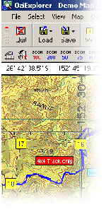
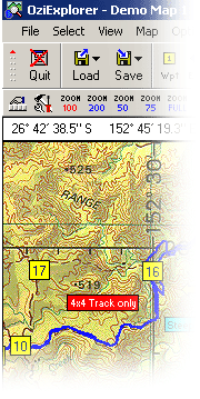
– OziExplorer allows you to work with maps on the computer screen that you create from scanned or digital maps. Ideal for planning trips for boating, 4 wheel driving, flying, hiking etc and as a real time navigation aid.
– OziExplorer is interactive, it allows you to work, on your computer screen, with digital maps that you have purchased or scanned yourself. By using these maps OziExplorer allows you to plan your trip by creating waypoints, routes and tracks on screen and upload these to your GPS.
With OziExplorer running and your laptop connected to your GPS, your GPS position is plotted on the map providing real time tracking ability (moving map). When you leave a map OziExplorer automatically changes to the next map.
Main Features
– View detailed Features List
– Use maps or charts which you scan yourself.
– Use maps in various formats which can be purchased in digital form (BSB, USGS DRG, ECW, SID, TIF, PNG, + more).
– Direct support for most Garmin, Magellan, Lowrance/Eagle, Brunton/Silva and MLR GPS receivers for Uploading and Downloading Waypoints, Routes and Tracks.
– Create Waypoints, Routes and Tracks on the map and upload these to your GPS (for supported GPS receivers).
– Download Waypoints, Routes and Tracks from your GPS and display them on a map (for supported GPS receivers).
– Specify permanent Map features on a map and attach a picture (or any other type of file) to each feature. Place symbols and comments on the Map.
– Over 100 map Datums supported.
– Support for many Map projections and Grid systems.
– Print Maps and Waypoint Lists.
– Show your GPS position in real time on the map (moving map).
– In moving map mode OziExplorer will navigate you along your chosen route giving instructions when each waypoint is reached. Various parameters such as Speed, Course, Next Waypoint, Distance, CTS, XTE, ETE and ETA are displayed.
– In moving map operation automatically changes to the next map.
– + much, much more.
– OziExplorer cannot upload maps to any GPS Receiver.
System Requirements
A PC running Windows 95/98/ME/NT4/2000/XP/Vista
For Upload/Download - Most Garmin, Magellan, Lowrance, Eagle, Brunton/Silva and MLR GPS receivers.
For Moving Map (real time tracking) Any GPS receiver which outputs NMEA 0183 sentences.
Maps of your particular area of the world which you purchase in digital form or can scan and calibrate yourself from paper charts.