


Navitel Navigator v8.5.35 Full + Maps

Navitel Navigator v8.5.35 Full + Maps
Center of Navigation Technologies | October 30, 2013 | Android | .apk | 105.8 MB
Center of Navigation Technologies | October 30, 2013 | Android | .apk | 105.8 MB
Navitel Navigator v8.5.35 Full + Maps
Navitel Navigator v8.5.35 Full + Maps

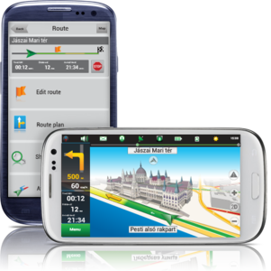
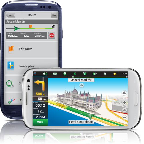
Navitel Navigator is a navigation system with support of the traffic jams and the most detailed maps of Russia, Europe, Turkey and Latin America.
Navigation maps of Andorra, Austria, Azerbaijan, Belgium, Switzerland, Germany, Denmark, Spain, Finland, France, Gibraltar, Italy, Liechtenstein, Luxembourg, Monaco, Malta, Netherlands, Norway, Portugal, San Marino, Sweden, Vatican, Albania, Belarus, Bosnia and Herzegovina, Bulgaria, Croatia, Czech Republic, Denmark, Estonia, Finland, Greece, Hungary, Kazakhstan, Kyrgyz Republic, Lithuania, Latvia, Macedonia, Montenegro, Maldives, Moldova, Norway, Poland, Romania, Russia, Serbia, Slovakia, Sweden, Turkey, Tajikistan, Ukraine, Uzbekistan.
Navitel v8 — a unique and accurate navigation system for smartphones and PDAs (PDA) equipped with GLONASS / GPS-receiver, with a special set of cards. In the navigation system NAVITEL Navigator Commonwealth uses detailed navigational maps of countries, with street names, house numbers, subway stations, gas stations, restaurants, the location of forests, rivers, lakes and other important and useful information. NAVITEL Navigator allows you to use the card, created and updated by the users themselves, in a popular cartographic editor GPSMapEdit. Among other functions, Navitel warn of approaching the place of attention (SPEEDCAM) and offer to reduce speed. The system - the most complete and detailed coverage of navigational charts of cities and regions of countries, 3-D-mode mapping of roads and highways, address street grid. Voice prompts, the best routes, traffic jams and detours… A huge database of useful objects POI metro stations, gas stations and all accompanying background information to facilitate orientation in the cities and surrounding towns.
What's in this version:
+ Free interactive service Navitel.Friends
+ Maps with high detail
+ Instant routing
+ Free online services "Navitel.Traffic", Navitel.Friends", Navitel.Events", "Navitel.SMS", "Navitel.Weather", Dynamic POI
+ Automatic maps update (free!)
+ Extensive POI database
+ 3D roads and 3D intersections
+ SpeedCam
+ Easy-to-use types of objects searching
+ Configurable interface
+ Android 1.6-4.x
Free LIVE Services:
Navitel.Traffic
Traffic information in real time for any location (via Internet);
Navitel.SMS
Exchange coordinates between users to define the location;
Navitel.Weather
Online weather forecast for any location and destination.
Dynamic POI
Actual information about different types of points of interest on the country map (gas stations, cinema, cafes and restaurants,etc.)
Navitel.Events
Fix and see on the map other users marks of the various types of road events (road accidents, road works, speed cameras).
Navitel.Friends
Navitel.Friends is an interactive service which provides an opportunity to see your friends' location on the map, chat or make a route to meet them.
Key Features:
Smart and clever route calculation;
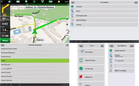
Multilanguage address search and voice guidance ;
High definition 3D visualization;
Automatic multi-point routes;
Smart address and POI search;
Navigate to a building, street, intersection ;
Extra fast map zooming;
2D and 3D map and POI displays;
Advanced turn-by-turn voice guidance;
Automatic day/night modes;
Auto screen orientation;
Advanced POI management;
Coordinate entry;
Track recording;
Customizable interface;
User`s safety cams and skins;
Entry Point routing;
GPS simulation in tunnels;
Calling POIs;
Smart History (Latest, Favorites);
Free quarterly map updates;
Up-to-dated high accuracy maps.
Intersections search;
Updated night skin for easier reading from display;
What's New in Navitel v8.5.35:
+ map subscription available;
+ vibration of the navigation device in response to use of the keyboard;
+ bugs occurring at POI search along the route are fixed;
+ traffic jams are rendered quicker in maps.
What's New in Navitel v8.0.0.267:
+ To Menu - Settings - Navitel.Friends added new option - "Hide irrelevant".
+ While installing the minimum values of map detail, buildings are displayed as single-storey.
+ Display of textures through the translucent building was fixed.
+ Rendering of colors and lighting of 3D models was improved.
+ Display of the houses' numbers in 3D mode was fixed.
+ Incorrect work of the program on devices Prestigio GeoVision 5500 was fixed.
What's New in Navitel v8.0:
+ Hardware-accelerated rendering is implemented (OpenGL)
+ New 3D maps with number of storeys support and textures
+ New 3D models of attractions
+ Brand POI
+ Traffic jams sensitivity setting
+ More detailed description of friends’ location on the map is implemented.
+ Zoom buttons bugs in "My Route" window were fixed.
+ Also other numerous minor fixes, enhancing the stability and reliability of the program, were made.
NOTE: Supports all the official maps (except Cyprus)!!!
Old versions! v8.0.0.267 | v8.0
Navitel Navigator for Windows Mobile!
Requires Android: 1.6 and up