

Leica Hexagon HxMap 4.1.0 with Tutorials

Leica Hexagon HxMap 4.1.0 with Tutorials | 1.9 Gb
The Leica Geosystems development team is pleased to announce the availability of HxMap 4.1 is used to produce geospatial data products within one single interface.
What's new in HxMap 4.1.0
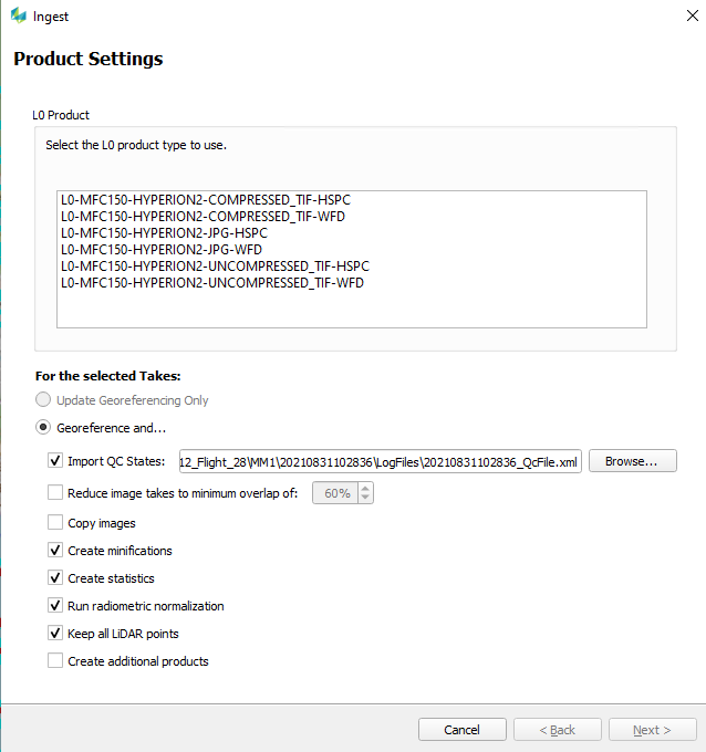
Create additional products during ingest
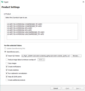
This version extends functionality of the ingest workflow step, allowing to queue up product generation jobs to be executed directly after ingesting completes. HxMap will allow the user to pick from any of the defined product templates if they are supported to be run in addition to ingest for the selected sensor types.
![Leica Hexagon HxMap 4.1.0 with Tutorials]()
New ingest dialog window
![Leica Hexagon HxMap 4.1.0 with Tutorials]()
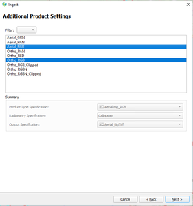
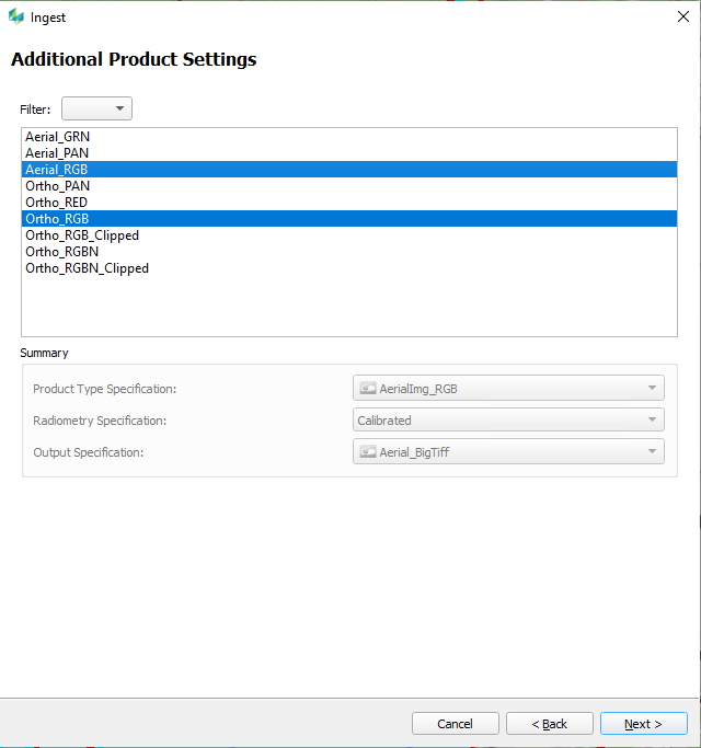
Selection of additional products to generate
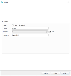
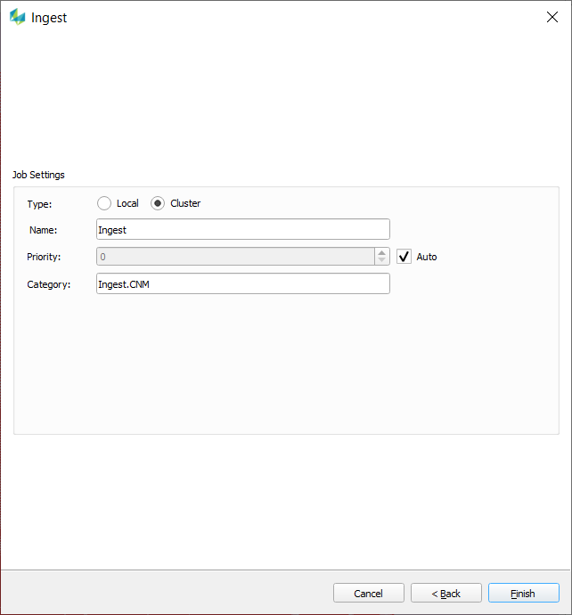
Adjust job settings when submitting to HTCondor
When processing HxMap data, most tasks support to be executed on a processing cluster. So far all jobs where submitted in order, leaving it to the user to manage the jobs within the processing queue manually. A new submission dialog window allows now to adjust the processing priority of a job already from within the workflow manager. This is then considered by HTCondor when the next job is selected for processing. Additionally, it is also possible to specify a processing category which can then be used to limit the number of nodes certain processing tasks consume.
![Leica Hexagon HxMap 4.1.0 with Tutorials]()
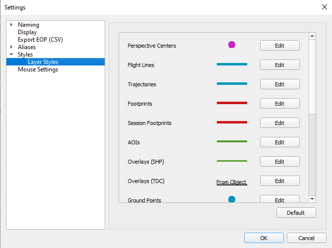
Customization of default layer styles
By default HxMap will use a set of pre-configured styles for each of the layers within the different perspectives. A new section in the HxMap application settings will now allow the user to change these styles to their personal preference.

![Leica Hexagon HxMap 4.1.0 with Tutorials]()
In addition to changing the default styles, it is also possible to change the style for each loaded layer. Such individual changes can now also be stored within the workspace file.
Dynamic layer styles for ground point layer in AT
Thanks to the changes in the layer styling, it is now also possible to adjust how each of the ground point layer is visualized. Additionally, HxMap will dynamically update the icons used to show the user if a point has been measured already or if it has been deactivated within the points list.
3D building vertice editing
To refine building objects generated with HxMap a new vertice editing capabilities have been added to the 3D editor perspective. With this release it is now possible to select vertices and either delete them or use their height information as reference for adjustment of other building parts.
Copying of buildings
The 3D Editor now allows to copy buildings to the position of a selected anchor point. Doing so will carry over all attributes except for the GUID which is generated for the new object.
Moving of buildings and building parts
Complete buildings or selected vertices can now be moved in all directions.
Performance improvements
We continuously aim to improve the performance of HxMap by either reducing processing times or lowering the memory required for processing.
This release includes major improvements to the following areas:
- reduced memory consumption for block processing step in APM
- reduced memory consumption and improved processing time for HSPC ingest and noise filtering step
Other
- Without an AOI, HxMap will now consider the selection of images when generating an Infocloud product
- Added support for Australia’s GDA2020 datum
This version extends functionality of the ingest workflow step, allowing to queue up product generation jobs to be executed directly after ingesting completes. HxMap will allow the user to pick from any of the defined product templates if they are supported to be run in addition to ingest for the selected sensor types.
Leica Hexagon HxMap 4.1.0 with Tutorials
New ingest dialog window
Leica Hexagon HxMap 4.1.0 with Tutorials
Selection of additional products to generate
Adjust job settings when submitting to HTCondor
When processing HxMap data, most tasks support to be executed on a processing cluster. So far all jobs where submitted in order, leaving it to the user to manage the jobs within the processing queue manually. A new submission dialog window allows now to adjust the processing priority of a job already from within the workflow manager. This is then considered by HTCondor when the next job is selected for processing. Additionally, it is also possible to specify a processing category which can then be used to limit the number of nodes certain processing tasks consume.
Leica Hexagon HxMap 4.1.0 with Tutorials
Customization of default layer styles
By default HxMap will use a set of pre-configured styles for each of the layers within the different perspectives. A new section in the HxMap application settings will now allow the user to change these styles to their personal preference.
Leica Hexagon HxMap 4.1.0 with Tutorials
In addition to changing the default styles, it is also possible to change the style for each loaded layer. Such individual changes can now also be stored within the workspace file.
Dynamic layer styles for ground point layer in AT
Thanks to the changes in the layer styling, it is now also possible to adjust how each of the ground point layer is visualized. Additionally, HxMap will dynamically update the icons used to show the user if a point has been measured already or if it has been deactivated within the points list.
3D building vertice editing
To refine building objects generated with HxMap a new vertice editing capabilities have been added to the 3D editor perspective. With this release it is now possible to select vertices and either delete them or use their height information as reference for adjustment of other building parts.
Copying of buildings
The 3D Editor now allows to copy buildings to the position of a selected anchor point. Doing so will carry over all attributes except for the GUID which is generated for the new object.
Moving of buildings and building parts
Complete buildings or selected vertices can now be moved in all directions.
Performance improvements
We continuously aim to improve the performance of HxMap by either reducing processing times or lowering the memory required for processing.
This release includes major improvements to the following areas:
- reduced memory consumption for block processing step in APM
- reduced memory consumption and improved processing time for HSPC ingest and noise filtering step
Other
- Without an AOI, HxMap will now consider the selection of images when generating an Infocloud product
- Added support for Australia’s GDA2020 datum

Leica Hexagon HxMap 4.1.0 with Tutorials
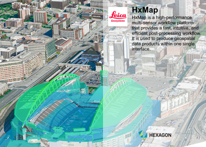
HxMap is a high-performance multi-sensor workflow platform that provides a fast, intuitive, and efficient post-processing workflow. It is used to produce geospatial data products within one single interface. It provides production tools that take raw flight datasets all the way through deliverable products refining radiometry and geometry along the process.
The user is guided through available workflow steps via the concept of task-oriented views (perspectives) within one central main window. Outputs created by HxMap are either image based or point based products that can be consumed by third party GIS applications.
3D City Model of Denver captured with Leica CityMapper
This 3D city model of Denver showcases how airborne data can be used for urban planning, risk analysis, geo-information and GIS. The data, captured with the Leica CityMapper and processed with HxMap, has been developed into an end-user application to visualise 3D urban data and rich information for consumption by the general public.
Hexagon is a global leader in digital reality solutions, combining sensor, software and autonomous technologies. We are putting data to work to boost efficiency, productivity, quality and safety across industrial, manufacturing, infrastructure, public sector, and mobility applications. Our technologies are shaping production and people-related ecosystems to become increasingly connected and autonomous – ensuring a scalable, sustainable future.
Leica Geosystems is part of Hexagon , a leading global provider of information technologies that drive quality and productivity improvements across geospatial and industrial enterprise applications.
Product: Leica Hexagon HxMap
Version: 4.1.0 with Tutorials
Supported Architectures: x64
Website Home Page : https://leica-geosystems.com/
Languages Supported: english
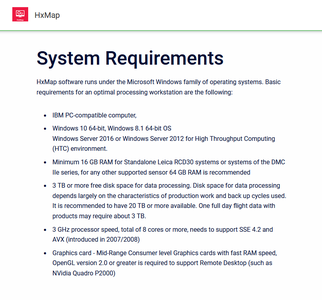
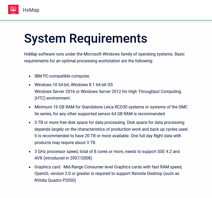
System Requirements: Windows *
Size: 1.9 Gb
Leica Hexagon HxMap 4.1.0 with Tutorials
Please visit my blog
Added by 3% of the overall size of the archive of information for the restoration
No mirrors please

![Leica Hexagon HxMap 4.1.0 with Tutorials]()
Added by 3% of the overall size of the archive of information for the restoration
No mirrors please
Leica Hexagon HxMap 4.1.0 with Tutorials
