

Geo-Plus VisionLidar 2020 version 30.0.01.116.20

Geo-Plus VisionLidar 2020 version 30.0.01.116.20 | 1.4 Gb
The Geo-Plus development team is pleased to announce the availability of VisionLidar 2020 is the best software made by surveyors for surveyors and civil engineers.

Geo-Plus VisionLidar 2020 version 30.0.01.116.20

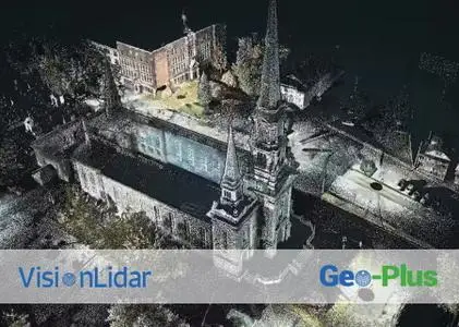
VisionLiDAR is designed to simplify and automate work for LiDAR point cloud and 3D image processing in the air, on the ground and in motion. Import your data from any scanner and get qualitative and intelligent point cloud skimming, intelligent complex volume calculation with tetrahedrons (for overhangs) and many others.
With VisionLiDAR, you now have a new and better way to acquire field data directly into your office. It offers many productivity and time saving tools like processing effectively over 100 billion points. Quickly and precisely calculate the volume between two surfaces, sections or complex volumes (overhangs), recognizing objects in a point cloud.
Classify your points intelligently to avoid losing the original data. Its unique object classification method facilitates virtual land surveying. Accurately calculate the size and circumference of a pipe from a point cloud, making your land surveys from a vectorized point cloud. Process your land, mobile and air points with the same software and easily share your site surveys from the point cloud to your CAD and vice versa and many more. With VisionLiDAR, you now have a new and better way to acquire field data directly into your office. Work in the comfort of your office!
New 2020 release is possible to visualize, process, classify, segment, animate, and edit Point Clouds in one single software : VisionLiDAR. No more restriction based on a maximum number of points; VisionLiDAR can read and process an infinite number of points to allow you to work with your massive Point Clouds in one single file. Process Point Clouds from ALS, TLS, and MLS for all your civil engineering, land surveying, architecture, BIM, transportation, mines, quarry, and forestry projects.
New version 2020 of VisionLidar point cloud and imagery processing software
In this pre-recorded Webinar, which took place on February 19, you will learn more about our company, you will have a summary of VisionLidar as well as its exclusive new features for the 2020 version.
Geo-Plus is widely known in the International software technology market in AEC (architecture, engineering, construction). Since the beginning of the business in 1987, thousands of worldwide clients have used our products and services.
Our Vision suite includes more than 16 3D measurement, 3D structure, geometry, cadastre and document management software related to the territories. Most of our software are fully integrated with AutoCAD, Civil3D, MicroStation, PowerDraft and Bricscad platforms. Our line of solutions is consistently at the forefront of CAD/GIS technology.
Product: Geo-Plus VisionLidar
Version: 2020 Ultimate (version 30.0.01.116.20)
Supported Architectures: x64
Website Home Page : www.geo-plus.com
Language: english
System Requirements: PC *
Size: 1.4 Gb
Hardware/Software requirements
RAM [GB] 16
HD [GB] 100
Use of GPU Y
Stereo Display N
List software environment, e.g. Microstation AutoCAD, BricsCAD, MicroStation, Powerdraft
Processor I7
Supported Systems ALS, MLS, TLS
Source of Point Clouds Airborne Lidar, Indoor TLS, Outdoor TLS, Photogrammetric, Radar
RAM [GB] 16
HD [GB] 100
Use of GPU Y
Stereo Display N
List software environment, e.g. Microstation AutoCAD, BricsCAD, MicroStation, Powerdraft
Processor I7
Supported Systems ALS, MLS, TLS
Source of Point Clouds Airborne Lidar, Indoor TLS, Outdoor TLS, Photogrammetric, Radar
Please visit my blog
Added by 3% of the overall size of the archive of information for the restoration
No mirrors please

![Geo-Plus VisionLidar 2020 version 30.0.01.116.20]()
Added by 3% of the overall size of the archive of information for the restoration
No mirrors please
Geo-Plus VisionLidar 2020 version 30.0.01.116.20
