

City Navigator Europe NT Unicode 2024.20

City Navigator Europe NT Unicode 2024.20 | 19.08 GB
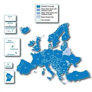
Navigate the streets of Europe with confidence. This product provides detailed road and landmark maps for your compatible device, so you can navigate with precise guidance, turn-by-turn to any address or intersection. Directions to restaurants, gas stations, lodging, attractions and more. Includes full coverage of Romania, Guadeloupe, Martinique, Saint Barthelemy and French Guiana. Detailed coverage for Bosnia and Herzegovina has increased. Includes more than 10.8 million km (6.7 million miles) of roads, including motorways, national and regional highways and local roads, in Western Europe and many Eastern European countries. Displays over 6.7 million points of interest across the country, including restaurants, lodging, border crossings, attractions, gas stations, campsites, shops and much more. Provides turn-by-turn directions on your compatible device. Pronunciation for compatible devices that speak street names (for example, "Turn right on Main Street"). Includes navigation features such as avoiding unwanted areas, choosing a route view, and more. Contains traffic data for compatible devices that use receiver traffic.
UK and Ireland
UK: Full Coverage
Scotland: Full Coverage
Wales: Full Coverage
Isle of Man: Full Coverage
Northern Ireland: Full Coverage
Ireland: Full Coverage
Channel Islands: Full Coverage
Denmark, Finland, Iceland, Norway and Sweden
Denmark: Full Coverage
Finland: Full Coverage Coverage
Iceland: Full Coverage
Norway: Full Coverage
Sweden: Full Coverage
France and Benelux
Andorra: Full Coverage
Belgium: Full Coverage
France: Full Coverage
French Guiana: Coverage for most urban areas
Guadeloupe: Full Coverage
Martinique: Full Coverage
Netherlands: Full Coverage
Luxembourg: Full Coverage
Reunion: Coverage for most urban areas
St. Barthelemy: Full Coverage
Italy, Austria, Switzerland and Liechtenstein
Italy: Full Coverage
Austria: Full Coverage
Switzerland: Full Coverage
Liechtenstein: Full Coverage
Malta
Malta : Full information
Spain and Portugal
Spain: Full coverage
Portugal: Full coverage
Gibraltar: Full coverage
Azores: Full coverage
Canary Islands: Full coverage
Baleric Islands: Full coverage
Madeira: Full information
Germany
Germany: Full Coverage
Czech Republic Czech Republic
: Full Coverage
Greece Greece
: Full Coverage
Eastern Europe
Estonia: Full Coverage
Latvia: Full Coverage
Lithuania: Full Coverage
Poland: Full Coverage
Slovakia: Full Coverage
Hungary: Full Coverage
Slovenia: Full Coverage
Croatia: Full Coverage
Bulgaria : Full coverage
Romania: Full coverage
Turkey: Full coverage
Cyprus: Full coverage
Moldova: Coverage for most urban areas
Bosnia and Herzegovina: Full coverage
Serbia and Kosovo: Full coverage
Montenegro: Full coverage
Albania: Main roads only
Republic of Macedonia (FYROM): Full coverage
Belarus: Coverage for most urban areas
Ukraine: Full coverage
In distribution:
In this version, the official map is divided into two files: Northern and Southern Europe.
Northern includes : Austria, Belarus, Belgium, Czech Republic, Denmark, Estonia, Finland, Germany, Iceland, Great Britain, Latvia, Lithuania, Luxembourg, the Netherlands, Norway, Poland, Slovakia, Sweden and Ukraine.
Southern includes : Albania, Andorra, Bosnia and Herzegovina, Bulgaria, Croatia, Cyprus, France, Greece, Hungary, Italy, Kosovo, Macedonia, Malta, Moldova, Montenegro, Portugal, Romania, Serbia, Slovenia, Spain, Switzerland and Turkey.
The accompanying files are now also separate for each of the card halves and are located in the corresponding folders.
In the "Unlocked IMG" folder the map file is unlocked and ready for copying to Garmin navigators.
In the "PC install Unlocked" folder there is a map for use in the "BaseCamp" and "MapSource" programs.
In these programs, you can select the area of Europe you are interested in and save it as an .img file on a navigator connected to your computer or just a flash drive with the Garmin folder in the root.
To install on your computer, simply copy the folder “City_Navigator_Europe_NTU_2024_20.gmap” to the path below (depending on your computer OS):
for WinXP the path is C:\Documents and Settings\All Users\Application Data\GARMIN\Maps
for Win7/8/10 path C:\ProgramData\Garmin\Maps
Additional Information:
On new Garmin navigators, such as nuvi 55/56/65/66/25x9/26x9, zumo 590, GPSMAP 64, Edge 1000 etc. another method of protection began to be used, the functionality of unlocked cards from a distribution depends on the firmware installed in the device, but in most cases it will need to be patched so that the navigator can use even unlocked cards from a given distribution.
The program and instructions (in English) for patching firmware can be downloaded here .
Materials on the correct installation of files from the distribution into the navigator can be found at links [1] , [2] and [3] .
A list of devices that support Unicode cards can be found here (Compatible Devices tab).
To determine which files from the "Additional Files" folder your device supports, you need to open the garmindevice.xml file in the Garmin folder, in the device's internal memory, and press CTRL-F to set the file extension, for example JCV. If it is listed, your machine supports Junction View.
System requirements : Garmin devices with Unicode support (since 2013). Model range 2xxx, 3xxx and others.
System requirements : Garmin navigators, as well as a PC with the "BaseCamp" or "MapSource" program installed
Version : 2024.20
FID : 12126
Homepage