

AutoCAD Map 3D 2022 with Offline Help
AutoCAD Map 3D 2022 with Offline Help | 41.4 Gb
Languages: English, Português-Brasil, Čeština, Français, Deutsch, Magyar, Italiano,
日本語, 한국어, Polski, Русский, 简体中文, Español, 繁體中文
Languages: English, Português-Brasil, Čeština, Français, Deutsch, Magyar, Italiano,
日本語, 한국어, Polski, Русский, 简体中文, Español, 繁體中文
The software developer Autodesk announced the launch of AutoCAD Map 3D 2022 is designed to help you utilise and maintain CAD and GIS data to support planning, design, and data management, whilst enabling access to multiple external data sources.
AutoCAD Map 3D 2022 Release Notes - Date: March 23, 2021
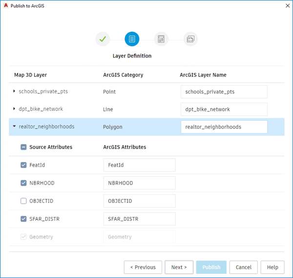
Publish to ArcGIS (What's New in 2022)
Publish your FDO vector layer data to ArcGIS Online or ArcGIS Enterprise portal.
When you select and define the layers from one or multiple FDO providers, a new feature layer is created after publishing to ArcGIS.

![AutoCAD Map 3D 2022 with Offline Help]()
Note: Image layers and feature classes with compound geometry type are not supported when publishing to ArcGIS.
Export to FGDB (What's New in 2022)
Export FDO vector layer data to a file geodatabase (FGDB) format.
Specify the layer data to export and then specify the name and location for the file geodatabase. You can use the FGDB file in ArcGIS or share directly with others.
The MAPEXPORTTOFGDB command saves the file geodatabase to a specified folder and it does not require an ArcGIS account or publishing privileges.
Coordinate System for ArcGIS Connector (What's New in 2022)
The MAPARCGISCONNECTORCSOPTION command allows you to specify the coordinate system to use when importing data from ArcGIS.

![AutoCAD Map 3D 2022 with Offline Help]()
The 1 Default option indicates that the LL84 coordinate system is used. When you find the data from ArcGIS is not correctly located after adding to Map, select 2 Drawing option to use the current drawing’s coordinate system or 3 CS Code to specify another coordinate system and import the data again.
Coordinate System Update (What's New in 2022)
Based on customer feedback, we've made changes to some coordinate systems.
- Implemented the UK local grid coordinate systems.
- Corrected the Netherlands-RDNew and TM75.IrishGrid coordinate system definitions.
- User-defined transformation path with a user-defined datum no longer fails.
- Updated the information for DeutscheBahn.Gauss3d-2, DeutscheBahn.Gauss3d-3, DeutscheBahn.Gauss3d-4 and DeutscheBahn.Gauss3d-5 coordinate systems.
Other enhancements
Extended support for the following FDO providers to newer versions:
- FDO PostgreSQL: PostgreSQL 12.2+ PostGIS 3.0
- ESRI ArcGIS: ArcGIS 10.8.1
The following customer issues have been resolved in AutoCAD Map 3D 2022 toolset.
ArcGIS Online
- Checking in new features to ArcGIS Online for layers that allow Add and Update Attributes only editing may cause Map 3D to crash.
- The latest submission to ArcGIS Online becomes invalid when the previous submission was rejected and canceled by the user.
- Some feature layer from ArcGIS Online cannot be added to the map drawing.
Industry Models
- Some strings in local language builds are truncated in the Workflow: Create duct template and Coordinate export dialog boxes.
- Unexpected hatches in some layers when plotting to PDF.
- For NA Electric, Finding Connected Features fails when the last step is to add the start feature. It resets the trace direction to the default value.
- Map 3D may crash when two or more fly-ins are derived from the Autodesk.Map.IM.FOrms.FlyIns.DocumentFlyIn.
- The filter in the SQLTextBox on Form doesn’t work as expected.
- Topology checker list displays the topology name instead of the topology caption.
- Some missing icons from the Data Checker dialog box and the form of compound feature class.
- IntersectionReport.ico doesn’t work as expected.
- In a table view, sorting on a column with Combo Box control type doesn't sort the list according to its value.
- Generating graphic for SQL Server industry models works slowly.
- Generating graphic may not work as expected if a layer in the display model contains joins.
- Changing Job state for some Industry Model data may cause Map 3D to crash.
MAPTOACAD
- MAPTOACAD may cause a crash when the layer contains a filter with an invalid attribute.
- Circle symbols are stretched or compressed in the DWG output of MAPTOACAD.
- The same symbol in the display model may get different block name in the DWG output of MAPTOACAD.
- When AutoCAD Map 3D is installed side-by-side with Autodesk Civil 3D, MAPTOACAD may fail the next time it uses the .dwt file.
Other issues
- Reopening DWG with saved FDO connection to SHP and ArcGIS GDB displays a broken layer connection.
- Converting symbols to XML gets additional color attribute.
- Save to Source Drawings may crash when multiple users are simultaneously working on the same attached drawing.
- The line weight for hatch is not editable in the Style Polygon dialog box.
- The attribute list checkbox in MAPEXPORT doesn’t fully support displays with high DPI.
- When the Properties palette is docked, the features cannot be deselected.
Publish your FDO vector layer data to ArcGIS Online or ArcGIS Enterprise portal.
When you select and define the layers from one or multiple FDO providers, a new feature layer is created after publishing to ArcGIS.
AutoCAD Map 3D 2022 with Offline Help
Note: Image layers and feature classes with compound geometry type are not supported when publishing to ArcGIS.
Export to FGDB (What's New in 2022)
Export FDO vector layer data to a file geodatabase (FGDB) format.
Specify the layer data to export and then specify the name and location for the file geodatabase. You can use the FGDB file in ArcGIS or share directly with others.
The MAPEXPORTTOFGDB command saves the file geodatabase to a specified folder and it does not require an ArcGIS account or publishing privileges.
Coordinate System for ArcGIS Connector (What's New in 2022)
The MAPARCGISCONNECTORCSOPTION command allows you to specify the coordinate system to use when importing data from ArcGIS.
AutoCAD Map 3D 2022 with Offline Help

The 1 Default option indicates that the LL84 coordinate system is used. When you find the data from ArcGIS is not correctly located after adding to Map, select 2 Drawing option to use the current drawing’s coordinate system or 3 CS Code to specify another coordinate system and import the data again.
Coordinate System Update (What's New in 2022)
Based on customer feedback, we've made changes to some coordinate systems.
- Implemented the UK local grid coordinate systems.
- Corrected the Netherlands-RDNew and TM75.IrishGrid coordinate system definitions.
- User-defined transformation path with a user-defined datum no longer fails.
- Updated the information for DeutscheBahn.Gauss3d-2, DeutscheBahn.Gauss3d-3, DeutscheBahn.Gauss3d-4 and DeutscheBahn.Gauss3d-5 coordinate systems.
Other enhancements
Extended support for the following FDO providers to newer versions:
- FDO PostgreSQL: PostgreSQL 12.2+ PostGIS 3.0
- ESRI ArcGIS: ArcGIS 10.8.1
The following customer issues have been resolved in AutoCAD Map 3D 2022 toolset.
ArcGIS Online
- Checking in new features to ArcGIS Online for layers that allow Add and Update Attributes only editing may cause Map 3D to crash.
- The latest submission to ArcGIS Online becomes invalid when the previous submission was rejected and canceled by the user.
- Some feature layer from ArcGIS Online cannot be added to the map drawing.
Industry Models
- Some strings in local language builds are truncated in the Workflow: Create duct template and Coordinate export dialog boxes.
- Unexpected hatches in some layers when plotting to PDF.
- For NA Electric, Finding Connected Features fails when the last step is to add the start feature. It resets the trace direction to the default value.
- Map 3D may crash when two or more fly-ins are derived from the Autodesk.Map.IM.FOrms.FlyIns.DocumentFlyIn.
- The filter in the SQLTextBox on Form doesn’t work as expected.
- Topology checker list displays the topology name instead of the topology caption.
- Some missing icons from the Data Checker dialog box and the form of compound feature class.
- IntersectionReport.ico doesn’t work as expected.
- In a table view, sorting on a column with Combo Box control type doesn't sort the list according to its value.
- Generating graphic for SQL Server industry models works slowly.
- Generating graphic may not work as expected if a layer in the display model contains joins.
- Changing Job state for some Industry Model data may cause Map 3D to crash.
MAPTOACAD
- MAPTOACAD may cause a crash when the layer contains a filter with an invalid attribute.
- Circle symbols are stretched or compressed in the DWG output of MAPTOACAD.
- The same symbol in the display model may get different block name in the DWG output of MAPTOACAD.
- When AutoCAD Map 3D is installed side-by-side with Autodesk Civil 3D, MAPTOACAD may fail the next time it uses the .dwt file.
Other issues
- Reopening DWG with saved FDO connection to SHP and ArcGIS GDB displays a broken layer connection.
- Converting symbols to XML gets additional color attribute.
- Save to Source Drawings may crash when multiple users are simultaneously working on the same attached drawing.
- The line weight for hatch is not editable in the Style Polygon dialog box.
- The attribute list checkbox in MAPEXPORT doesn’t fully support displays with high DPI.
- When the Properties palette is docked, the features cannot be deselected.
AutoCAD Map 3D 2022 with Offline Help
AutoCAD 2022 features several industry-specific toolsets, such as Architecture, Mechanical, and Electrical, that have libraries containing hundreds of thousands of intelligent parts, symbols, and features. Autodesk conducted productivity studies to track how designers can save time with these specialized toolsets.
Map 3D Toolset
Looking to publish your FDO vector layer data to ArcGIS Online or Portal for ArcGIS Enterprise? With the AutoCAD 2022 updates to the Map 3D toolset, you can do exactly that. You can also choose to export the FDO vector layer data to a file geodatabase (FGDB), which can be used in ArcGIS or shared directly with others.
You can specify what coordinate system to use when importing data from ArcGIS with the introduction of the new MAPARCGISCONNECTORCSOPTION command.
Based on user feedback, we’ve made several enhancements to some coordinate systems in AutoCAD 2022:
- Implemented the UK local grid coordinate systems
- Corrected the Netherlands-RDNew and TM75.IrishGrid coordinate system definitions
- User-defined transformation path with a user-defined datum no longer fails
- Updated the information for DeutscheBahn.Gauss3d-2, DeutscheBahn.Gauss3d-3, DeutscheBahn.Gauss3d-4, and DeutscheBahn.Gauss3d-5 coordinate systems.
Plus, we have extended support for the following FDO providers to newer versions:
- FDO PostgreSQL: PostgreSQL 12.2+ PostGIS 3.0
- ESRI ArcGIS: ArcGIS 10.8.1
AutoCAD Map 3D for Engineers
Autodesk helps people imagine, design and create a better world. Everyone—from design professionals, engineers and architects to digital artists, students and hobbyists—uses Autodesk software to unlock their creativity and solve important challenges.
Product: AutoCAD Map 3D
Version: 2022 with Offline Help *
Supported Architectures: x64
Website Home Page : www.autodesk.com
Language: multilanguage
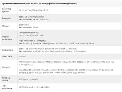
System Requirements: PC **
Size: 41.4 Gb
AutoCAD_Map_2022_xxxxxxx_Win_64bit_dlm_001_002.sfx.exe
AutoCAD_Map_2022_xxxxxxx_Win_64bit_dlm_002_002.sfx.exe
autocad_map_3d_2022_api_references.zip
autocad_map_2022_help_xxxxxxx_win_64bit_dlm.sfx.exe
Note: xxxxxxx - Languages: English, Português-Brasil, Čeština, Français, Deutsch, Magyar, Italiano, 日本語, 한국어, Polski, Русский, 简体中文, Español, 繁體中文
AutoCAD_Map_2022_xxxxxxx_Win_64bit_dlm_002_002.sfx.exe
autocad_map_3d_2022_api_references.zip
autocad_map_2022_help_xxxxxxx_win_64bit_dlm.sfx.exe
Note: xxxxxxx - Languages: English, Português-Brasil, Čeština, Français, Deutsch, Magyar, Italiano, 日本語, 한국어, Polski, Русский, 简体中文, Español, 繁體中文
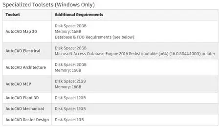
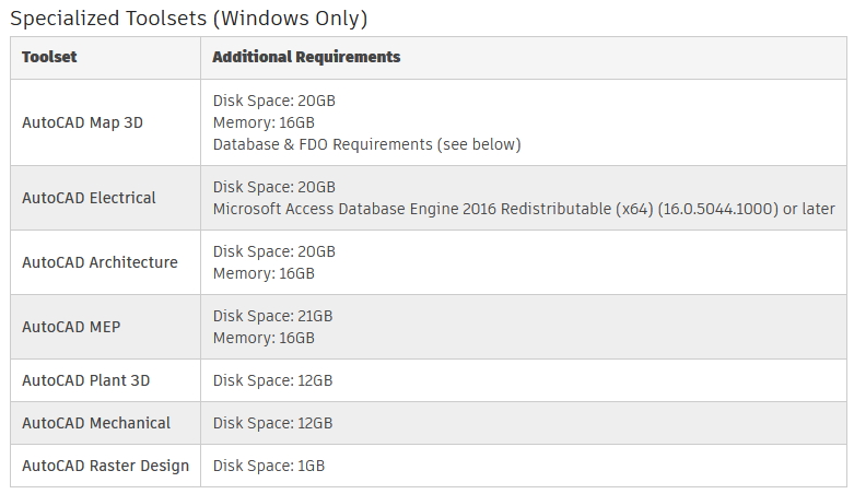
System requirements for AutoCAD 2022 including Specialized Toolsets
![AutoCAD Map 3D 2022 with Offline Help]()
![AutoCAD Map 3D 2022 with Offline Help]()
AutoCAD Map 3D 2022 with Offline Help

AutoCAD Map 3D 2022 with Offline Help
Please visit my blog
Added by 3% of the overall size of the archive of information for the restoration
No mirrors please

![AutoCAD Map 3D 2022 with Offline Help]()
Added by 3% of the overall size of the archive of information for the restoration
No mirrors please
AutoCAD Map 3D 2022 with Offline Help
