

Aquaveo Groundwater Modeling System (GMS) 10.8.3

Aquaveo Groundwater Modeling System (GMS) 10.8.3 | 946.2 mb
Aquaveo, a water resources consulting company, is pleased to announce availability Groundwater Modeling System (GMS) 10.8.3 is the most advanced software system available for performing groundwater simulations in a three-dimensional environment.
What's New in GMS 10.8.3 - February 07, 2024
Grid
14927 Pass through cells display is random in single layer view
Observations
14935 Flow Observations Aren't Showing Up in GMS
Rasters
14632 The quartile method of populating contour values fails for raster
MODFLOW
14930 GUI Test: SAMG+ solver not licensed error even with active license
14963 Raster > Array With Low Resolution Is Interpolating 0s to the Array
14971 GUI Test: Use Seep Elevation checkbox doesn't stay enabled
Online Maps
14794 GUI Test: Can't see map from new source
Map
14948 Converting specifc shapefile to feautre objects causes a crash
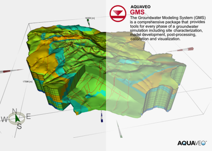
The Groundwater Modeling System (GMS) is a comprehensive graphical user environment for performing groundwater simulations. The entire GMS system consists of a graphical user interface (the GMS program) and a number of analysis codes (MODFLOW, MT3DMS, etc.). GMS was designed as a comprehensive modeling environment. Several types of models are supported and facilities are provided to share information between different models and data types. Tools are provided for site characterization, model conceptualization, mesh and grid generation, geostatistics, and post-processing.
GMS
Instructional videos for the Groundwater Modeling System (GMS) program developed by Aquaveo.
Aquaveo is a pioneer of GIS-based software solutions for hydraulic, hydrologic and groundwater modeling. Our products have been refined over two decades to create the most advanced environmental modeling and visualization software available. In addition to interfacing with industry standard numerical models, we develop custom desktop and cloud-based applications tailored to specific needs. Aquaveo began as a part of the Engineering Computer Graphics Laboratory at Brigham Young University in 1985. The lab was reorganized and the name was changed in September, 1998 to the Environmental Modeling Research Laboratory (EMRL). In April, 2007, the main software development team at EMRL entered private enterprise as Aquaveo, LLC.
Owner: Aquaveo
Product Name: Groundwater Modeling System (GMS)
Version: 10.8.3 Premium
Supported Architectures: x64
Website Home Page : www.aquaveo.com
Languages Supported: english
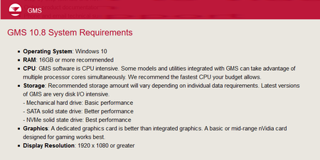
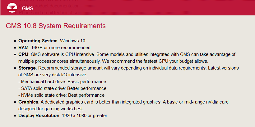
System Requirements: Windows *
Size: 946.2 mb
Aquaveo Groundwater Modeling System (GMS) 10.8.3
Please visit my blog
Added by 3% of the overall size of the archive of information for the restoration
No mirrors please

![Aquaveo Groundwater Modeling System (GMS) 10.8.3]()
Added by 3% of the overall size of the archive of information for the restoration
No mirrors please
Aquaveo Groundwater Modeling System (GMS) 10.8.3
