

National Geographic - Maps Print Collection
National Geographic - Maps Print Collection
8 JPEG | 6000X4000 | 96DPI | 72MB
8 JPEG | 6000X4000 | 96DPI | 72MB
World Political Map
This latest world map from the cartographers at National Geographic features subtle border coloring on land and prevailing winds and ocean currents at sea. Separate insets show the North and South Polar Regions, world vegetation and land use, and world population density.
World Political Map (Earth-toned)
This latest world map from the cartographers at National Geographic is elegantly portrayed in rich, earth-toned colors and features the Winkel Tripel projection to reduce the distortion of land masses as they near the poles. Separate insets show the North and South Polar Regions, world vegetation and land use, and world population density.
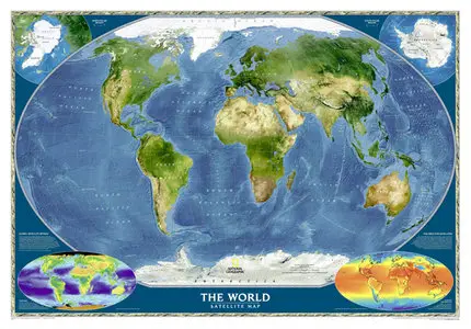
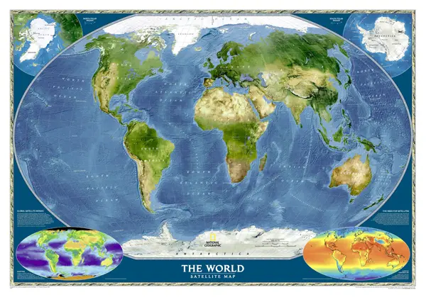
World Satellite Map
The most accurate map of Earth's surface ever produced from satellite data. This computer-generated composite map draws from more than 500 satellite images to give one-kilometer detail and consistent representation of natural colors.
Earth's Fractured Surface Map
Like the pieces of a jigsaw puzzle, slabs of rocky crust known as tectonic plates fit together to form the outer shell of the Earth. This world map shows the continents along with the lines of each tectonic plate, demonstrating the reaction between continental drift, earthquakes and volcanoes.
Antarctica Map
Loaded with information about Antarctica—including expeditions, stations, wildlife, climate, and more—this map also contains inset maps showing the subglacial continent and various countries' claims on the region. Published in April 1987, this map accompanied the "Pinnipeds Around the World" map and an article entitled "Seal and Their Kin," which appeared in the same issue.
Europe Political Map
This map provides a look at the modern European continent.
North America Political Map
This map provides a look at the modern North American continent.
South America Political Map
This map provides a look at the modern South American continent.
http://maps.nationalgeographic.com/maps/print-collection/
Download @ Rapidshare